You are here: Home > Network List > CI - Caltech Regional Seismic Network Stations List
> Station NEE Needles, California, USA > Earthquake Result Viewer
NEE Needles, California, USA - Earthquake Result Viewer
| Earthquake location: |
Tonga Islands |
| Earthquake latitude/longitude: |
-16.9/-174.2 |
| Earthquake time(UTC): |
2000/01/08 (008) 16:47:20 GMT |
| Earthquake Depth: |
183 km |
| Earthquake Magnitude: |
6.5 MB, 6.6 MS, 7.2 MW, 7.0 ME |
| Earthquake Catalog/Contributor: |
WHDF/NEIC |
|
| Network: |
CI Caltech Regional Seismic Network |
| Station: |
NEE Needles, California, USA |
| Lat/Lon: |
34.82 N/114.60 W |
| Elevation: |
139 m |
|
| Distance: |
76.5 deg |
| Az: |
46.896 deg |
| Baz: |
238.158 deg |
| Ray Param: |
0.050487127 |
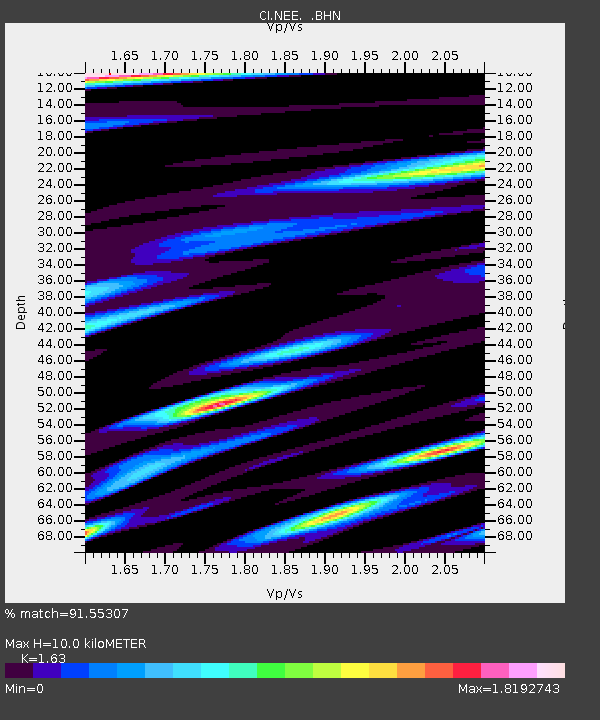
| Estimated Moho Depth: |
10.0 km |
| Estimated Crust Vp/Vs: |
1.63 |
| Assumed Crust Vp: |
6.276 km/s |
| Estimated Crust Vs: |
3.85 km/s |
| Estimated Crust Poisson's Ratio: |
0.20 |
|
| Radial Match: |
91.55307 % |
| Radial Bump: |
400 |
| Transverse Match: |
93.076904 % |
| Transverse Bump: |
400 |
| SOD ConfigId: |
3753 |
| Insert Time: |
2010-02-25 21:11:13.013 +0000 |
| GWidth: |
2.5 |
| Max Bumps: |
400 |
| Tol: |
0.001 |
|
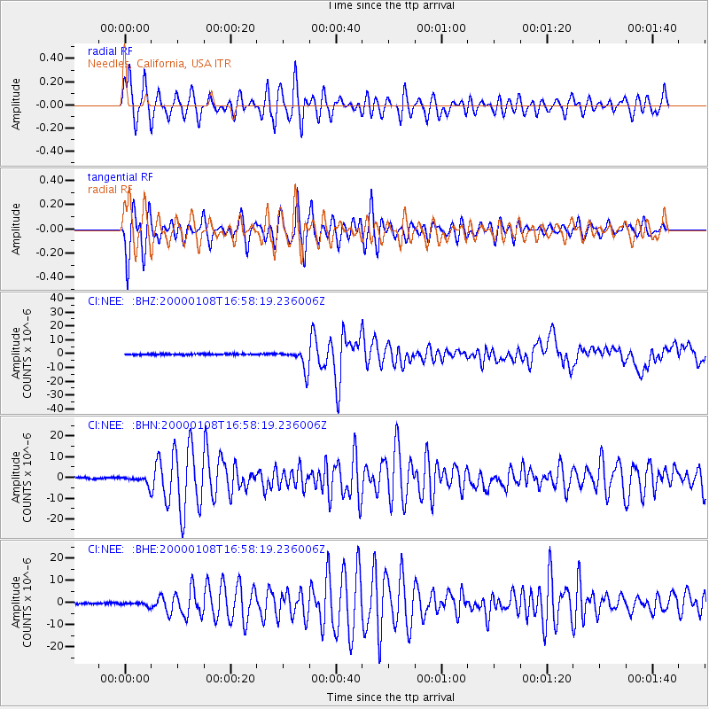
Signal To Noise
| Channel | StoN | STA | LTA |
| CI:NEE: :BHN:20000108T16:58:19.236006Z | 5.3950806 | 2.2299694E-6 | 4.1333382E-7 |
| CI:NEE: :BHE:20000108T16:58:19.236006Z | 2.3106446 | 8.5299587E-7 | 3.6915924E-7 |
| CI:NEE: :BHZ:20000108T16:58:19.236006Z | 16.623571 | 7.78622E-6 | 4.683843E-7 |
| Arrivals |
| Ps | 1.0 SECOND |
| PpPs | 4.1 SECOND |
| PsPs/PpSs | 5.1 SECOND |


