You are here: Home > Network List > UW - Pacific Northwest Regional Seismic Network Stations List
> Station YACT Amboy, WA, USA > Earthquake Result Viewer
YACT Amboy, WA, USA - Earthquake Result Viewer
| Earthquake location: |
Near Coast Of Chiapas, Mexico |
| Earthquake latitude/longitude: |
14.7/-92.4 |
| Earthquake time(UTC): |
2014/07/07 (188) 11:23:55 GMT |
| Earthquake Depth: |
60 km |
| Earthquake Magnitude: |
6.9 MWW, 6.9 MWC, 7.1 MI |
| Earthquake Catalog/Contributor: |
NEIC PDE/NEIC COMCAT |
|
| Network: |
UW Pacific Northwest Regional Seismic Network |
| Station: |
YACT Amboy, WA, USA |
| Lat/Lon: |
45.93 N/122.42 W |
| Elevation: |
211 m |
|
| Distance: |
40.0 deg |
| Az: |
327.125 deg |
| Baz: |
131.194 deg |
| Ray Param: |
0.074470654 |
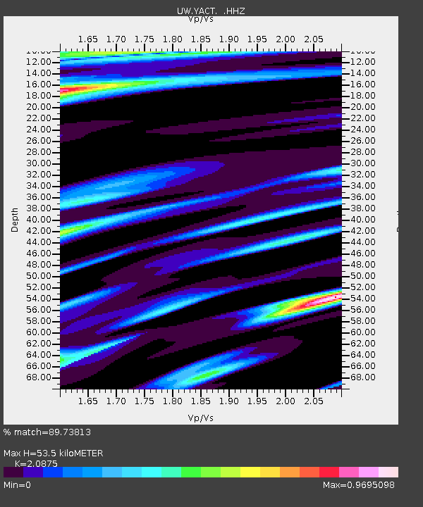
| Estimated Moho Depth: |
53.5 km |
| Estimated Crust Vp/Vs: |
2.09 |
| Assumed Crust Vp: |
6.566 km/s |
| Estimated Crust Vs: |
3.145 km/s |
| Estimated Crust Poisson's Ratio: |
0.35 |
|
| Radial Match: |
89.73813 % |
| Radial Bump: |
400 |
| Transverse Match: |
76.93567 % |
| Transverse Bump: |
400 |
| SOD ConfigId: |
751272 |
| Insert Time: |
2014-07-21 12:22:50.933 +0000 |
| GWidth: |
2.5 |
| Max Bumps: |
400 |
| Tol: |
0.001 |
|

Signal To Noise
| Channel | StoN | STA | LTA |
| UW:YACT: :HHZ:20140707T11:30:54.097999Z | 32.580597 | 2.833988E-6 | 8.698392E-8 |
| UW:YACT: :HHN:20140707T11:30:54.097999Z | 11.390553 | 1.1535881E-6 | 1.0127586E-7 |
| UW:YACT: :HHE:20140707T11:30:54.097999Z | 12.920456 | 1.0924542E-6 | 8.45523E-8 |
| Arrivals |
| Ps | 9.4 SECOND |
| PpPs | 24 SECOND |
| PsPs/PpSs | 33 SECOND |


