You are here: Home > Network List > WI - West Indies IPGP Network Stations List
> Station SAM Savane Anatole - Martinique > Earthquake Result Viewer
SAM Savane Anatole - Martinique - Earthquake Result Viewer
| Earthquake location: |
Near Coast Of Chiapas, Mexico |
| Earthquake latitude/longitude: |
14.7/-92.4 |
| Earthquake time(UTC): |
2014/07/07 (188) 11:23:55 GMT |
| Earthquake Depth: |
60 km |
| Earthquake Magnitude: |
6.9 MWW, 6.9 MWC, 7.1 MI |
| Earthquake Catalog/Contributor: |
NEIC PDE/NEIC COMCAT |
|
| Network: |
WI West Indies IPGP Network |
| Station: |
SAM Savane Anatole - Martinique |
| Lat/Lon: |
14.84 N/61.17 W |
| Elevation: |
510 m |
|
| Distance: |
30.2 deg |
| Az: |
85.759 deg |
| Baz: |
273.874 deg |
| Ray Param: |
0.07931235 |
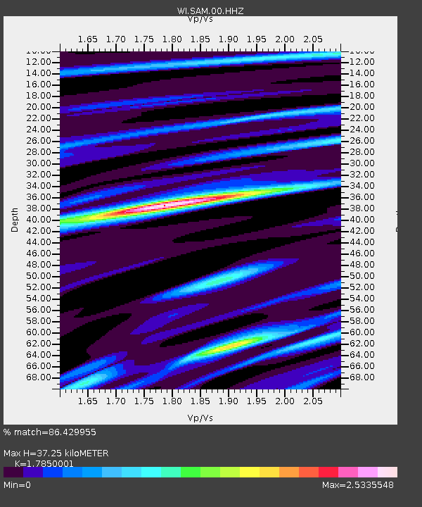
| Estimated Moho Depth: |
37.25 km |
| Estimated Crust Vp/Vs: |
1.79 |
| Assumed Crust Vp: |
5.88 km/s |
| Estimated Crust Vs: |
3.294 km/s |
| Estimated Crust Poisson's Ratio: |
0.27 |
|
| Radial Match: |
86.429955 % |
| Radial Bump: |
400 |
| Transverse Match: |
84.45705 % |
| Transverse Bump: |
400 |
| SOD ConfigId: |
751272 |
| Insert Time: |
2014-07-21 12:23:13.298 +0000 |
| GWidth: |
2.5 |
| Max Bumps: |
400 |
| Tol: |
0.001 |
|
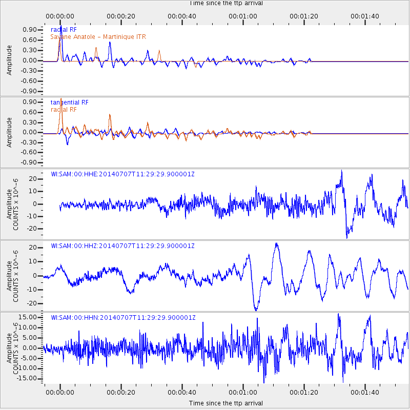
Signal To Noise
| Channel | StoN | STA | LTA |
| WI:SAM:00:HHZ:20140707T11:29:29.900001Z | 8.472119 | 5.011054E-6 | 5.914759E-7 |
| WI:SAM:00:HHN:20140707T11:29:29.900001Z | 1.3343867 | 1.9695826E-6 | 1.4760209E-6 |
| WI:SAM:00:HHE:20140707T11:29:29.900001Z | 1.9355319 | 3.6709203E-6 | 1.8965951E-6 |
| Arrivals |
| Ps | 5.3 SECOND |
| PpPs | 17 SECOND |
| PsPs/PpSs | 22 SECOND |


