You are here: Home > Network List > US - United States National Seismic Network Stations List
> Station HAWA Hanford, Washington, USA > Earthquake Result Viewer
HAWA Hanford, Washington, USA - Earthquake Result Viewer
*The percent match for this event was below the threshold and hence no stack was calculated.
| Earthquake location: |
Southeastern China |
| Earthquake latitude/longitude: |
26.7/108.8 |
| Earthquake time(UTC): |
2015/03/30 (089) 01:47:36 GMT |
| Earthquake Depth: |
20 km |
| Earthquake Magnitude: |
5.4 mb, 5.4 mb, 5.8 MS |
| Earthquake Catalog/Contributor: |
ISC/ISC |
|
| Network: |
US United States National Seismic Network |
| Station: |
HAWA Hanford, Washington, USA |
| Lat/Lon: |
46.39 N/119.53 W |
| Elevation: |
364 m |
|
| Distance: |
95.1 deg |
| Az: |
31.271 deg |
| Baz: |
317.882 deg |
| Ray Param: |
$rayparam |
*The percent match for this event was below the threshold and hence was not used in the summary stack. |
|
| Radial Match: |
70.48823 % |
| Radial Bump: |
244 |
| Transverse Match: |
83.76408 % |
| Transverse Bump: |
315 |
| SOD ConfigId: |
7422571 |
| Insert Time: |
2019-04-17 23:31:58.447 +0000 |
| GWidth: |
2.5 |
| Max Bumps: |
400 |
| Tol: |
0.001 |
|
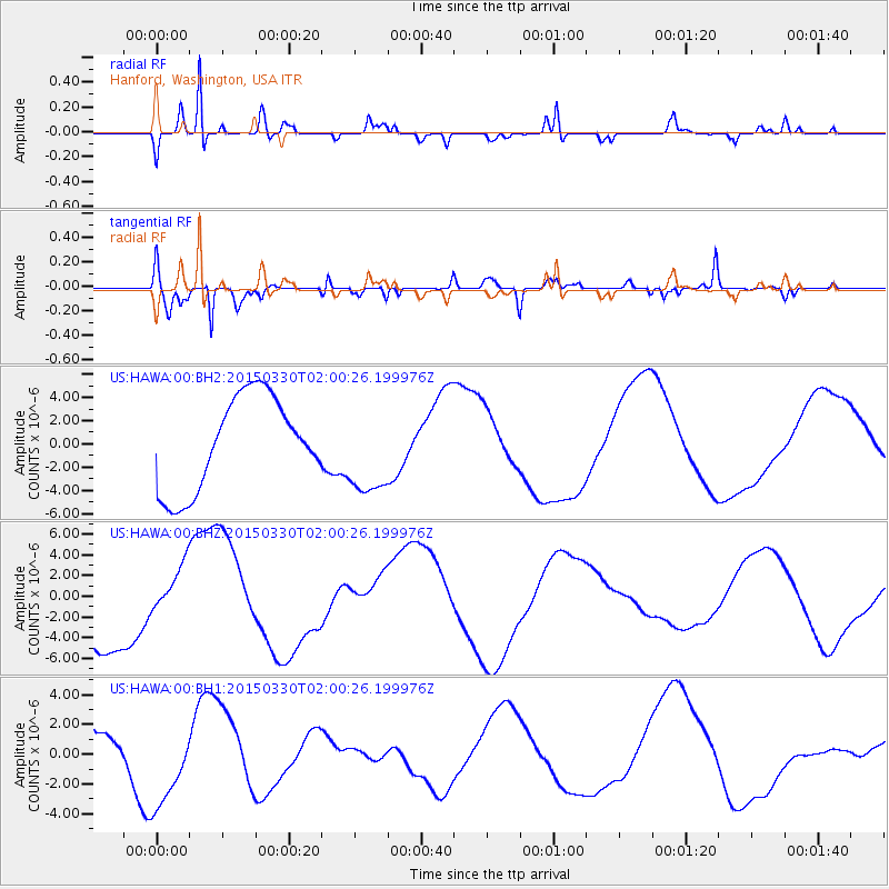
Signal To Noise
| Channel | StoN | STA | LTA |
| US:HAWA:00:BHZ:20150330T02:00:26.199976Z | 0.66067064 | 2.2528761E-6 | 3.4099837E-6 |
| US:HAWA:00:BH1:20150330T02:00:26.199976Z | 2.9768097 | 2.9944158E-6 | 1.0059144E-6 |
| US:HAWA:00:BH2:20150330T02:00:26.199976Z | 0.9727401 | 3.865316E-6 | 3.973637E-6 |
| Arrivals |
| Ps | |
| PpPs | |
| PsPs/PpSs | |


