You are here: Home > Network List > C1 - Red Sismologica Nacional Stations List
> Station MT02 Curacavi > Earthquake Result Viewer
MT02 Curacavi - Earthquake Result Viewer
| Earthquake location: |
Near Coast Of Chiapas, Mexico |
| Earthquake latitude/longitude: |
14.7/-92.4 |
| Earthquake time(UTC): |
2014/07/07 (188) 11:23:55 GMT |
| Earthquake Depth: |
60 km |
| Earthquake Magnitude: |
6.9 MWW, 6.9 MWC, 7.1 MI |
| Earthquake Catalog/Contributor: |
NEIC PDE/NEIC COMCAT |
|
| Network: |
C1 Red Sismologica Nacional |
| Station: |
MT02 Curacavi |
| Lat/Lon: |
33.26 S/71.14 W |
| Elevation: |
338 m |
|
| Distance: |
51.9 deg |
| Az: |
157.269 deg |
| Baz: |
333.501 deg |
| Ray Param: |
0.06696043 |
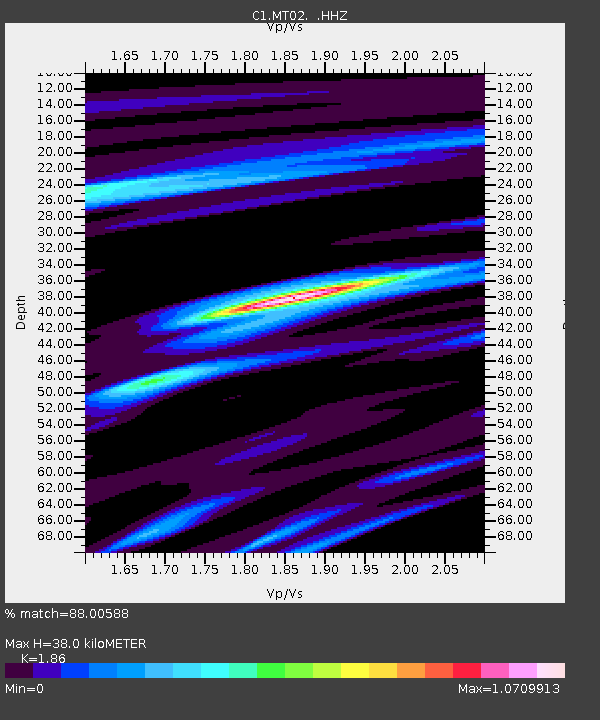
| Estimated Moho Depth: |
38.0 km |
| Estimated Crust Vp/Vs: |
1.86 |
| Assumed Crust Vp: |
6.481 km/s |
| Estimated Crust Vs: |
3.484 km/s |
| Estimated Crust Poisson's Ratio: |
0.30 |
|
| Radial Match: |
88.00588 % |
| Radial Bump: |
326 |
| Transverse Match: |
71.60342 % |
| Transverse Bump: |
400 |
| SOD ConfigId: |
751272 |
| Insert Time: |
2014-07-21 12:26:47.432 +0000 |
| GWidth: |
2.5 |
| Max Bumps: |
400 |
| Tol: |
0.001 |
|

Signal To Noise
| Channel | StoN | STA | LTA |
| C1:MT02: :HHZ:20140707T11:32:27.16999Z | 15.410173 | 8.762021E-6 | 5.685868E-7 |
| C1:MT02: :HHN:20140707T11:32:27.16999Z | 13.675669 | 4.6021028E-6 | 3.3651756E-7 |
| C1:MT02: :HHE:20140707T11:32:27.16999Z | 7.8282943 | 1.9961496E-6 | 2.5499168E-7 |
| Arrivals |
| Ps | 5.3 SECOND |
| PpPs | 16 SECOND |
| PsPs/PpSs | 21 SECOND |


