You are here: Home > Network List > AK - Alaska Regional Network Stations List
> Station CUT Chulitna, AK, USA > Earthquake Result Viewer
CUT Chulitna, AK, USA - Earthquake Result Viewer

| Earthquake location: |
Hokkaido, Japan Region |
| Earthquake latitude/longitude: |
42.7/141.4 |
| Earthquake time(UTC): |
2014/07/08 (189) 09:05:23 GMT |
| Earthquake Depth: |
10 km |
| Earthquake Magnitude: |
5.6 MB, 5.5 MWB |
| Earthquake Catalog/Contributor: |
NEIC PDE/NEIC COMCAT |
|
| Network: |
AK Alaska Regional Network |
| Station: |
CUT Chulitna, AK, USA |
| Lat/Lon: |
62.41 N/150.26 W |
| Elevation: |
574 m |
|
| Distance: |
43.6 deg |
| Az: |
38.893 deg |
| Baz: |
276.123 deg |
| Ray Param: |
0.0724694 |
| Estimated Moho Depth: |
26.0 km |
| Estimated Crust Vp/Vs: |
1.86 |
| Assumed Crust Vp: |
6.438 km/s |
| Estimated Crust Vs: |
3.466 km/s |
| Estimated Crust Poisson's Ratio: |
0.30 |
|
| Radial Match: |
82.06417 % |
| Radial Bump: |
400 |
| Transverse Match: |
81.70499 % |
| Transverse Bump: |
400 |
| SOD ConfigId: |
751272 |
| Insert Time: |
2014-07-22 09:12:34.982 +0000 |
| GWidth: |
2.5 |
| Max Bumps: |
400 |
| Tol: |
0.001 |
|
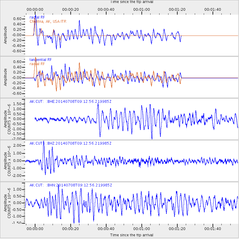
Signal To Noise
| Channel | StoN | STA | LTA |
| AK:CUT: :BHZ:20140708T09:12:56.219985Z | 6.234317 | 6.018204E-7 | 9.653348E-8 |
| AK:CUT: :BHN:20140708T09:12:56.219985Z | 1.0772384 | 2.0119124E-7 | 1.8676575E-7 |
| AK:CUT: :BHE:20140708T09:12:56.219985Z | 1.7532502 | 2.2039406E-7 | 1.25706E-7 |
| Arrivals |
| Ps | 3.7 SECOND |
| PpPs | 11 SECOND |
| PsPs/PpSs | 15 SECOND |


