You are here: Home > Network List > TA - USArray Transportable Network (new EarthScope stations) Stations List
> Station I59A Olmsteadville, NY, USA > Earthquake Result Viewer
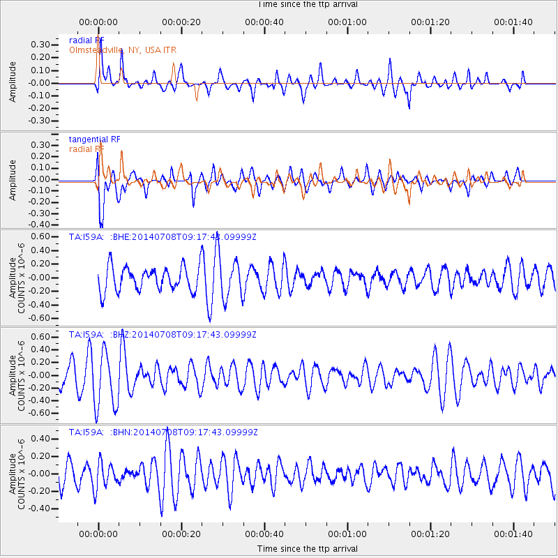
I59A Olmsteadville, NY, USA - Earthquake Result Viewer
*The percent match for this event was below the threshold and hence no stack was calculated.
| Earthquake location: |
Hokkaido, Japan Region |
| Earthquake latitude/longitude: |
42.7/141.4 |
| Earthquake time(UTC): |
2014/07/08 (189) 09:05:23 GMT |
| Earthquake Depth: |
10 km |
| Earthquake Magnitude: |
5.6 MB, 5.5 MWB |
| Earthquake Catalog/Contributor: |
NEIC PDE/NEIC COMCAT |
|
| Network: |
TA USArray Transportable Network (new EarthScope stations) |
| Station: |
I59A Olmsteadville, NY, USA |
| Lat/Lon: |
43.80 N/73.87 W |
| Elevation: |
390 m |
|
| Distance: |
88.3 deg |
| Az: |
24.739 deg |
| Baz: |
334.776 deg |
| Ray Param: |
$rayparam |
*The percent match for this event was below the threshold and hence was not used in the summary stack. |
|
| Radial Match: |
46.727467 % |
| Radial Bump: |
370 |
| Transverse Match: |
77.86671 % |
| Transverse Bump: |
400 |
| SOD ConfigId: |
751272 |
| Insert Time: |
2014-07-22 09:38:33.249 +0000 |
| GWidth: |
2.5 |
| Max Bumps: |
400 |
| Tol: |
0.001 |
|
Signal To Noise
| Channel | StoN | STA | LTA |
| TA:I59A: :BHZ:20140708T09:17:43.09999Z | 2.4364612 | 4.4994852E-7 | 1.8467297E-7 |
| TA:I59A: :BHN:20140708T09:17:43.09999Z | 1.4214643 | 1.4768324E-7 | 1.0389515E-7 |
| TA:I59A: :BHE:20140708T09:17:43.09999Z | 1.5683088 | 2.7543578E-7 | 1.7562598E-7 |
| Arrivals |
| Ps | |
| PpPs | |
| PsPs/PpSs | |


