You are here: Home > Network List > TA - USArray Transportable Network (new EarthScope stations) Stations List
> Station L44A Lake County Forest Preserve, Grayslake, IL, USA > Earthquake Result Viewer
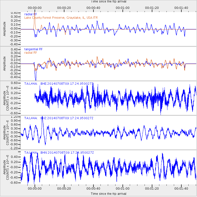
L44A Lake County Forest Preserve, Grayslake, IL, USA - Earthquake Result Viewer
*The percent match for this event was below the threshold and hence no stack was calculated.
| Earthquake location: |
Hokkaido, Japan Region |
| Earthquake latitude/longitude: |
42.7/141.4 |
| Earthquake time(UTC): |
2014/07/08 (189) 09:05:23 GMT |
| Earthquake Depth: |
10 km |
| Earthquake Magnitude: |
5.6 MB, 5.5 MWB |
| Earthquake Catalog/Contributor: |
NEIC PDE/NEIC COMCAT |
|
| Network: |
TA USArray Transportable Network (new EarthScope stations) |
| Station: |
L44A Lake County Forest Preserve, Grayslake, IL, USA |
| Lat/Lon: |
42.18 N/87.91 W |
| Elevation: |
202 m |
|
| Distance: |
84.6 deg |
| Az: |
34.49 deg |
| Baz: |
325.822 deg |
| Ray Param: |
$rayparam |
*The percent match for this event was below the threshold and hence was not used in the summary stack. |
|
| Radial Match: |
47.948456 % |
| Radial Bump: |
400 |
| Transverse Match: |
78.04948 % |
| Transverse Bump: |
400 |
| SOD ConfigId: |
751272 |
| Insert Time: |
2014-07-22 09:39:17.821 +0000 |
| GWidth: |
2.5 |
| Max Bumps: |
400 |
| Tol: |
0.001 |
|
Signal To Noise
| Channel | StoN | STA | LTA |
| TA:L44A: :BHZ:20140708T09:17:24.950027Z | 2.3023243 | 4.262586E-7 | 1.8514272E-7 |
| TA:L44A: :BHN:20140708T09:17:24.950027Z | 1.3497909 | 3.1523973E-7 | 2.3354707E-7 |
| TA:L44A: :BHE:20140708T09:17:24.950027Z | 1.2603322 | 2.0366211E-7 | 1.6159399E-7 |
| Arrivals |
| Ps | |
| PpPs | |
| PsPs/PpSs | |


