You are here: Home > Network List > RV - Regional Alberta Seismic Observatory for Earthquake Studies Network Stations List
> Station RDEA Red Earth Creek, AB > Earthquake Result Viewer
RDEA Red Earth Creek, AB - Earthquake Result Viewer
| Earthquake location: |
New Ireland Region, P.N.G. |
| Earthquake latitude/longitude: |
-5.1/153.1 |
| Earthquake time(UTC): |
2015/03/30 (089) 01:51:26 GMT |
| Earthquake Depth: |
43 km |
| Earthquake Magnitude: |
4.6 mb, 4.6 mb |
| Earthquake Catalog/Contributor: |
ISC/ISC |
|
| Network: |
RV Regional Alberta Seismic Observatory for Earthquake Studies Network |
| Station: |
RDEA Red Earth Creek, AB |
| Lat/Lon: |
56.55 N/115.32 W |
| Elevation: |
530 m |
|
| Distance: |
95.1 deg |
| Az: |
33.761 deg |
| Baz: |
268.56 deg |
| Ray Param: |
0.040854674 |
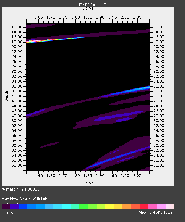
| Estimated Moho Depth: |
17.75 km |
| Estimated Crust Vp/Vs: |
1.60 |
| Assumed Crust Vp: |
6.53 km/s |
| Estimated Crust Vs: |
4.082 km/s |
| Estimated Crust Poisson's Ratio: |
0.18 |
|
| Radial Match: |
94.08362 % |
| Radial Bump: |
400 |
| Transverse Match: |
97.30848 % |
| Transverse Bump: |
273 |
| SOD ConfigId: |
7422571 |
| Insert Time: |
2019-04-17 23:39:17.218 +0000 |
| GWidth: |
2.5 |
| Max Bumps: |
400 |
| Tol: |
0.001 |
|

Signal To Noise
| Channel | StoN | STA | LTA |
| RV:RDEA: :HHZ:20150330T02:04:13.070029Z | 0.8138094 | 1.01849355E-5 | 1.2515136E-5 |
| RV:RDEA: :HHN:20150330T02:04:13.070029Z | 1.6782964 | 1.878103E-5 | 1.1190532E-5 |
| RV:RDEA: :HHE:20150330T02:04:13.070029Z | 1.6195757 | 9.11533E-6 | 5.6282206E-6 |
| Arrivals |
| Ps | 1.7 SECOND |
| PpPs | 6.9 SECOND |
| PsPs/PpSs | 8.6 SECOND |


