You are here: Home > Network List > TA - USArray Transportable Network (new EarthScope stations) Stations List
> Station J01E Myrtle Point, OR, USA > Earthquake Result Viewer
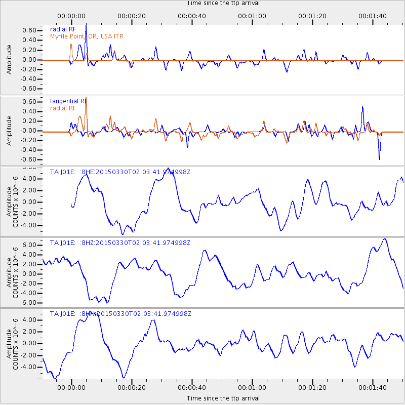
J01E Myrtle Point, OR, USA - Earthquake Result Viewer
*The percent match for this event was below the threshold and hence no stack was calculated.
| Earthquake location: |
New Ireland Region, P.N.G. |
| Earthquake latitude/longitude: |
-5.1/153.1 |
| Earthquake time(UTC): |
2015/03/30 (089) 01:51:26 GMT |
| Earthquake Depth: |
43 km |
| Earthquake Magnitude: |
4.6 mb, 4.6 mb |
| Earthquake Catalog/Contributor: |
ISC/ISC |
|
| Network: |
TA USArray Transportable Network (new EarthScope stations) |
| Station: |
J01E Myrtle Point, OR, USA |
| Lat/Lon: |
43.16 N/123.93 W |
| Elevation: |
128 m |
|
| Distance: |
88.3 deg |
| Az: |
46.601 deg |
| Baz: |
261.558 deg |
| Ray Param: |
$rayparam |
*The percent match for this event was below the threshold and hence was not used in the summary stack. |
|
| Radial Match: |
79.92158 % |
| Radial Bump: |
400 |
| Transverse Match: |
69.97127 % |
| Transverse Bump: |
400 |
| SOD ConfigId: |
7422571 |
| Insert Time: |
2019-04-17 23:39:29.148 +0000 |
| GWidth: |
2.5 |
| Max Bumps: |
400 |
| Tol: |
0.001 |
|
Signal To Noise
| Channel | StoN | STA | LTA |
| TA:J01E: :BHZ:20150330T02:03:41.974998Z | 0.7144407 | 2.0833832E-6 | 2.9161038E-6 |
| TA:J01E: :BHN:20150330T02:03:41.974998Z | 1.1836557 | 3.2535843E-6 | 2.748759E-6 |
| TA:J01E: :BHE:20150330T02:03:41.974998Z | 1.7496821 | 5.600777E-6 | 3.2010255E-6 |
| Arrivals |
| Ps | |
| PpPs | |
| PsPs/PpSs | |


