You are here: Home > Network List > UW - Pacific Northwest Regional Seismic Network Stations List
> Station MRBL Marblemount, WA, USA > Earthquake Result Viewer
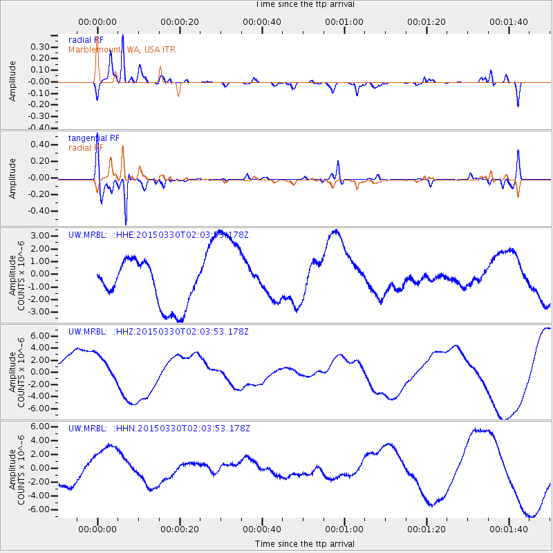
MRBL Marblemount, WA, USA - Earthquake Result Viewer
*The percent match for this event was below the threshold and hence no stack was calculated.
| Earthquake location: |
New Ireland Region, P.N.G. |
| Earthquake latitude/longitude: |
-5.1/153.1 |
| Earthquake time(UTC): |
2015/03/30 (089) 01:51:26 GMT |
| Earthquake Depth: |
43 km |
| Earthquake Magnitude: |
4.6 mb, 4.6 mb |
| Earthquake Catalog/Contributor: |
ISC/ISC |
|
| Network: |
UW Pacific Northwest Regional Seismic Network |
| Station: |
MRBL Marblemount, WA, USA |
| Lat/Lon: |
48.52 N/121.48 W |
| Elevation: |
75 m |
|
| Distance: |
90.7 deg |
| Az: |
41.517 deg |
| Baz: |
263.268 deg |
| Ray Param: |
$rayparam |
*The percent match for this event was below the threshold and hence was not used in the summary stack. |
|
| Radial Match: |
91.65823 % |
| Radial Bump: |
282 |
| Transverse Match: |
75.12252 % |
| Transverse Bump: |
356 |
| SOD ConfigId: |
7422571 |
| Insert Time: |
2019-04-17 23:40:14.288 +0000 |
| GWidth: |
2.5 |
| Max Bumps: |
400 |
| Tol: |
0.001 |
|
Signal To Noise
| Channel | StoN | STA | LTA |
| UW:MRBL: :HHZ:20150330T02:03:53.178Z | 0.76299375 | 2.3043128E-6 | 3.020094E-6 |
| UW:MRBL: :HHN:20150330T02:03:53.178Z | 2.4595237 | 3.414681E-6 | 1.3883506E-6 |
| UW:MRBL: :HHE:20150330T02:03:53.178Z | 2.2691147 | 3.858721E-6 | 1.7005402E-6 |
| Arrivals |
| Ps | |
| PpPs | |
| PsPs/PpSs | |


