You are here: Home > Network List > AK - Alaska Regional Network Stations List
> Station ATKA Atka Island Broadband > Earthquake Result Viewer
ATKA Atka Island Broadband - Earthquake Result Viewer
| Earthquake location: |
Off East Coast Of Honshu, Japan |
| Earthquake latitude/longitude: |
37.1/142.4 |
| Earthquake time(UTC): |
2014/07/11 (192) 19:22:00 GMT |
| Earthquake Depth: |
13 km |
| Earthquake Magnitude: |
6.8 MWP, 6.8 MI |
| Earthquake Catalog/Contributor: |
NEIC PDE/NEIC COMCAT |
|
| Network: |
AK Alaska Regional Network |
| Station: |
ATKA Atka Island Broadband |
| Lat/Lon: |
52.20 N/174.20 W |
| Elevation: |
55 m |
|
| Distance: |
33.9 deg |
| Az: |
49.438 deg |
| Baz: |
260.873 deg |
| Ray Param: |
0.078010574 |
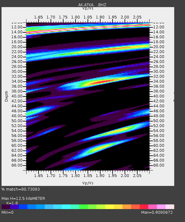
| Estimated Moho Depth: |
12.5 km |
| Estimated Crust Vp/Vs: |
1.80 |
| Assumed Crust Vp: |
5.88 km/s |
| Estimated Crust Vs: |
3.267 km/s |
| Estimated Crust Poisson's Ratio: |
0.28 |
|
| Radial Match: |
80.73083 % |
| Radial Bump: |
400 |
| Transverse Match: |
74.85261 % |
| Transverse Bump: |
400 |
| SOD ConfigId: |
751272 |
| Insert Time: |
2014-07-25 20:48:48.570 +0000 |
| GWidth: |
2.5 |
| Max Bumps: |
400 |
| Tol: |
0.001 |
|

Signal To Noise
| Channel | StoN | STA | LTA |
| AK:ATKA: :BHZ:20140711T19:28:11.627996Z | 5.2887974 | 2.2162933E-6 | 4.1905435E-7 |
| AK:ATKA: :BHN:20140711T19:28:11.627996Z | 1.1970035 | 6.4979866E-7 | 5.428544E-7 |
| AK:ATKA: :BHE:20140711T19:28:11.627996Z | 2.2740736 | 1.5391845E-6 | 6.768402E-7 |
| Arrivals |
| Ps | 1.8 SECOND |
| PpPs | 5.6 SECOND |
| PsPs/PpSs | 7.4 SECOND |


