You are here: Home > Network List > CI - Caltech Regional Seismic Network Stations List
> Station MPM Manuel Prospect Mine, California, USA > Earthquake Result Viewer
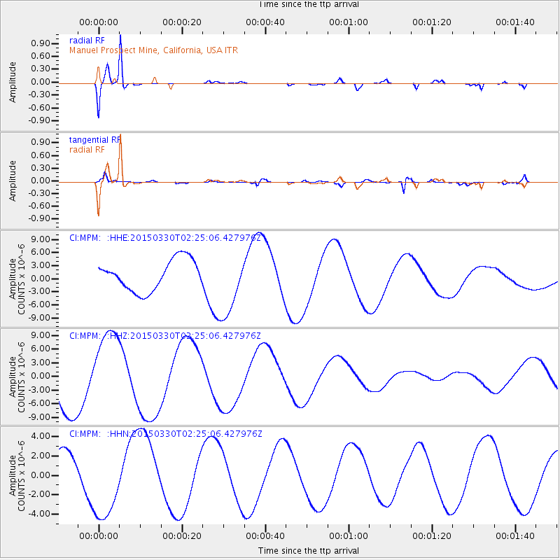
MPM Manuel Prospect Mine, California, USA - Earthquake Result Viewer
*The percent match for this event was below the threshold and hence no stack was calculated.
| Earthquake location: |
Southeast Of Loyalty Islands |
| Earthquake latitude/longitude: |
-22.5/170.8 |
| Earthquake time(UTC): |
2015/03/30 (089) 02:12:45 GMT |
| Earthquake Depth: |
42 km |
| Earthquake Magnitude: |
5.0 mb, 5.0 mb |
| Earthquake Catalog/Contributor: |
ISC/ISC |
|
| Network: |
CI Caltech Regional Seismic Network |
| Station: |
MPM Manuel Prospect Mine, California, USA |
| Lat/Lon: |
36.06 N/117.49 W |
| Elevation: |
185 m |
|
| Distance: |
89.3 deg |
| Az: |
50.303 deg |
| Baz: |
241.384 deg |
| Ray Param: |
$rayparam |
*The percent match for this event was below the threshold and hence was not used in the summary stack. |
|
| Radial Match: |
94.40406 % |
| Radial Bump: |
369 |
| Transverse Match: |
77.335815 % |
| Transverse Bump: |
400 |
| SOD ConfigId: |
7422571 |
| Insert Time: |
2019-04-17 23:42:28.524 +0000 |
| GWidth: |
2.5 |
| Max Bumps: |
400 |
| Tol: |
0.001 |
|
Signal To Noise
| Channel | StoN | STA | LTA |
| CI:MPM: :HHZ:20150330T02:25:06.427976Z | 1.6324549 | 9.450849E-6 | 5.789347E-6 |
| CI:MPM: :HHN:20150330T02:25:06.427976Z | 2.576761 | 4.151755E-6 | 1.6112302E-6 |
| CI:MPM: :HHE:20150330T02:25:06.427976Z | 2.1112974 | 7.3341184E-6 | 3.4737495E-6 |
| Arrivals |
| Ps | |
| PpPs | |
| PsPs/PpSs | |


