You are here: Home > Network List > CI - Caltech Regional Seismic Network Stations List
> Station SMM Simmler, CA, USA > Earthquake Result Viewer
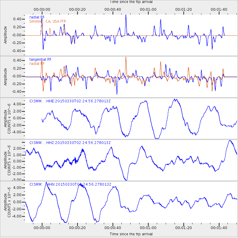
SMM Simmler, CA, USA - Earthquake Result Viewer
*The percent match for this event was below the threshold and hence no stack was calculated.
| Earthquake location: |
Southeast Of Loyalty Islands |
| Earthquake latitude/longitude: |
-22.5/170.8 |
| Earthquake time(UTC): |
2015/03/30 (089) 02:12:45 GMT |
| Earthquake Depth: |
42 km |
| Earthquake Magnitude: |
5.0 mb, 5.0 mb |
| Earthquake Catalog/Contributor: |
ISC/ISC |
|
| Network: |
CI Caltech Regional Seismic Network |
| Station: |
SMM Simmler, CA, USA |
| Lat/Lon: |
35.31 N/120.00 W |
| Elevation: |
599 m |
|
| Distance: |
87.2 deg |
| Az: |
49.95 deg |
| Baz: |
239.918 deg |
| Ray Param: |
$rayparam |
*The percent match for this event was below the threshold and hence was not used in the summary stack. |
|
| Radial Match: |
78.61275 % |
| Radial Bump: |
368 |
| Transverse Match: |
51.867577 % |
| Transverse Bump: |
289 |
| SOD ConfigId: |
7422571 |
| Insert Time: |
2019-04-17 23:42:36.190 +0000 |
| GWidth: |
2.5 |
| Max Bumps: |
400 |
| Tol: |
0.001 |
|
Signal To Noise
| Channel | StoN | STA | LTA |
| CI:SMM: :HHZ:20150330T02:24:56.278013Z | 0.26418248 | 7.4584847E-7 | 2.823232E-6 |
| CI:SMM: :HHN:20150330T02:24:56.278013Z | 1.4166235 | 3.6093384E-6 | 2.547846E-6 |
| CI:SMM: :HHE:20150330T02:24:56.278013Z | 1.6339285 | 2.7586466E-6 | 1.6883521E-6 |
| Arrivals |
| Ps | |
| PpPs | |
| PsPs/PpSs | |


