You are here: Home > Network List > GS - US Geological Survey Networks Stations List
> Station OK027 Henny and Sorgum Hills Rd. > Earthquake Result Viewer
OK027 Henny and Sorgum Hills Rd. - Earthquake Result Viewer
| Earthquake location: |
Off East Coast Of Honshu, Japan |
| Earthquake latitude/longitude: |
37.1/142.4 |
| Earthquake time(UTC): |
2014/07/11 (192) 19:22:00 GMT |
| Earthquake Depth: |
13 km |
| Earthquake Magnitude: |
6.8 MWP, 6.8 MI |
| Earthquake Catalog/Contributor: |
NEIC PDE/NEIC COMCAT |
|
| Network: |
GS US Geological Survey Networks |
| Station: |
OK027 Henny and Sorgum Hills Rd. |
| Lat/Lon: |
35.71 N/97.28 W |
| Elevation: |
364 m |
|
| Distance: |
88.9 deg |
| Az: |
44.62 deg |
| Baz: |
316.342 deg |
| Ray Param: |
0.042264797 |
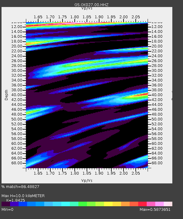
| Estimated Moho Depth: |
10.0 km |
| Estimated Crust Vp/Vs: |
1.84 |
| Assumed Crust Vp: |
6.426 km/s |
| Estimated Crust Vs: |
3.488 km/s |
| Estimated Crust Poisson's Ratio: |
0.29 |
|
| Radial Match: |
86.48827 % |
| Radial Bump: |
400 |
| Transverse Match: |
46.158337 % |
| Transverse Bump: |
400 |
| SOD ConfigId: |
751272 |
| Insert Time: |
2014-07-25 21:13:25.161 +0000 |
| GWidth: |
2.5 |
| Max Bumps: |
400 |
| Tol: |
0.001 |
|

Signal To Noise
| Channel | StoN | STA | LTA |
| GS:OK027:00:HHZ:20140711T19:34:22.528997Z | 9.911858 | 7.285384E-7 | 7.35017E-8 |
| GS:OK027:00:HH1:20140711T19:34:22.528997Z | 0.76446325 | 2.4464543E-7 | 3.2002248E-7 |
| GS:OK027:00:HH2:20140711T19:34:22.528997Z | 2.1760533 | 9.045181E-7 | 4.156691E-7 |
| Arrivals |
| Ps | 1.3 SECOND |
| PpPs | 4.3 SECOND |
| PsPs/PpSs | 5.7 SECOND |


