You are here: Home > Network List > CN - Canadian National Seismograph Network Stations List
> Station INK INUVIK, NT > Earthquake Result Viewer
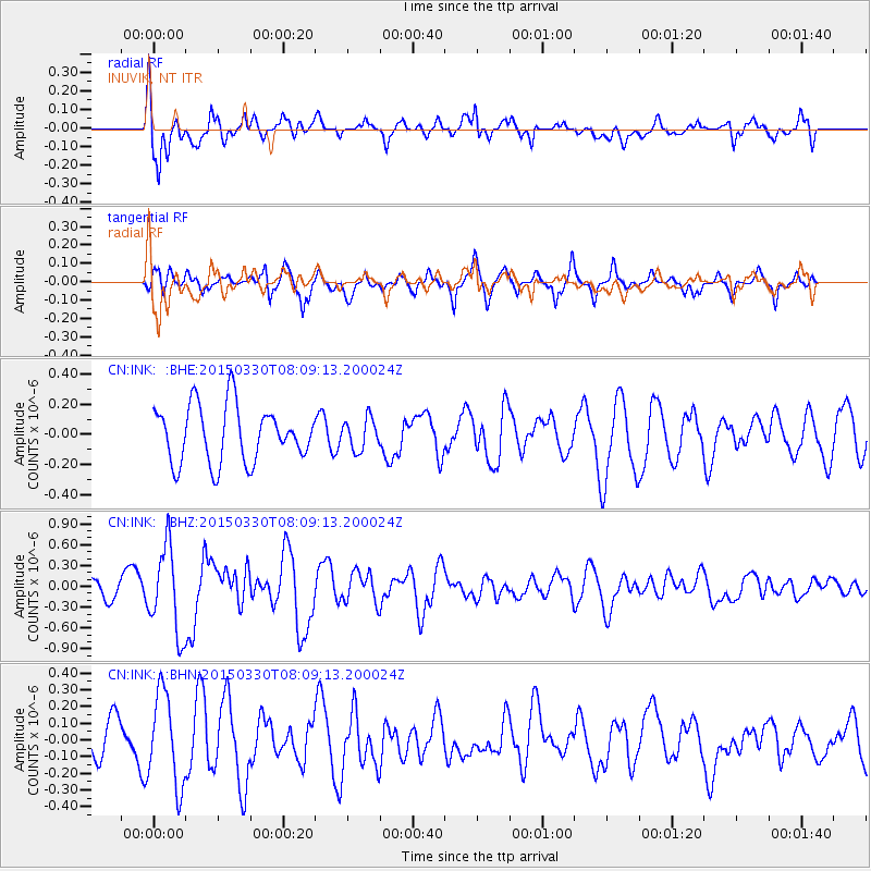
INK INUVIK, NT - Earthquake Result Viewer
*The percent match for this event was below the threshold and hence no stack was calculated.
| Earthquake location: |
Tonga Islands |
| Earthquake latitude/longitude: |
-15.4/-173.1 |
| Earthquake time(UTC): |
2015/03/30 (089) 07:56:54 GMT |
| Earthquake Depth: |
10 km |
| Earthquake Magnitude: |
5.6 MB |
| Earthquake Catalog/Contributor: |
NEIC PDE/NEIC COMCAT |
|
| Network: |
CN Canadian National Seismograph Network |
| Station: |
INK INUVIK, NT |
| Lat/Lon: |
68.31 N/133.53 W |
| Elevation: |
44 m |
|
| Distance: |
88.2 deg |
| Az: |
13.706 deg |
| Baz: |
217.923 deg |
| Ray Param: |
$rayparam |
*The percent match for this event was below the threshold and hence was not used in the summary stack. |
|
| Radial Match: |
70.69064 % |
| Radial Bump: |
400 |
| Transverse Match: |
68.56857 % |
| Transverse Bump: |
400 |
| SOD ConfigId: |
7422571 |
| Insert Time: |
2019-04-17 23:51:57.735 +0000 |
| GWidth: |
2.5 |
| Max Bumps: |
400 |
| Tol: |
0.001 |
|
Signal To Noise
| Channel | StoN | STA | LTA |
| CN:INK: :BHZ:20150330T08:09:13.200024Z | 3.3023672 | 6.2237694E-7 | 1.8846389E-7 |
| CN:INK: :BHN:20150330T08:09:13.200024Z | 1.7592876 | 2.7741712E-7 | 1.5768718E-7 |
| CN:INK: :BHE:20150330T08:09:13.200024Z | 0.56731576 | 1.0536029E-7 | 1.8571718E-7 |
| Arrivals |
| Ps | |
| PpPs | |
| PsPs/PpSs | |


