You are here: Home > Network List > IN - National Seismic Network of India Stations List
> Station SHL Shillong, Meghalaya, India > Earthquake Result Viewer
SHL Shillong, Meghalaya, India - Earthquake Result Viewer
| Earthquake location: |
Off East Coast Of Honshu, Japan |
| Earthquake latitude/longitude: |
37.1/142.4 |
| Earthquake time(UTC): |
2014/07/11 (192) 19:22:00 GMT |
| Earthquake Depth: |
13 km |
| Earthquake Magnitude: |
6.8 MWP, 6.8 MI |
| Earthquake Catalog/Contributor: |
NEIC PDE/NEIC COMCAT |
|
| Network: |
IN National Seismic Network of India |
| Station: |
SHL Shillong, Meghalaya, India |
| Lat/Lon: |
25.57 N/91.86 E |
| Elevation: |
2.0 m |
|
| Distance: |
44.2 deg |
| Az: |
269.88 deg |
| Baz: |
62.321 deg |
| Ray Param: |
0.072061844 |
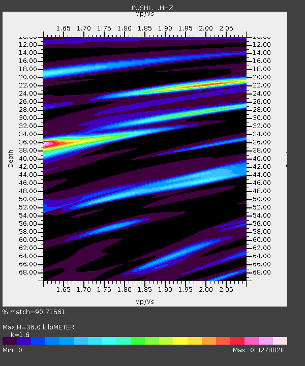
| Estimated Moho Depth: |
36.0 km |
| Estimated Crust Vp/Vs: |
1.60 |
| Assumed Crust Vp: |
6.273 km/s |
| Estimated Crust Vs: |
3.921 km/s |
| Estimated Crust Poisson's Ratio: |
0.18 |
|
| Radial Match: |
90.71561 % |
| Radial Bump: |
309 |
| Transverse Match: |
70.18136 % |
| Transverse Bump: |
400 |
| SOD ConfigId: |
751272 |
| Insert Time: |
2014-07-25 21:17:26.027 +0000 |
| GWidth: |
2.5 |
| Max Bumps: |
400 |
| Tol: |
0.001 |
|

Signal To Noise
| Channel | StoN | STA | LTA |
| IN:SHL: :HHZ:20140711T19:29:37.940007Z | 48.112698 | 7.2776706E-6 | 1.51263E-7 |
| IN:SHL: :HHN:20140711T19:29:37.940007Z | 14.727432 | 2.038081E-6 | 1.3838672E-7 |
| IN:SHL: :HHE:20140711T19:29:37.940007Z | 41.623802 | 4.195425E-6 | 1.0079388E-7 |
| Arrivals |
| Ps | 3.7 SECOND |
| PpPs | 14 SECOND |
| PsPs/PpSs | 18 SECOND |


