You are here: Home > Network List > TA - USArray Transportable Network (new EarthScope stations) Stations List
> Station I23K Minto, Yukon-Koyukuk, AK, USA > Earthquake Result Viewer
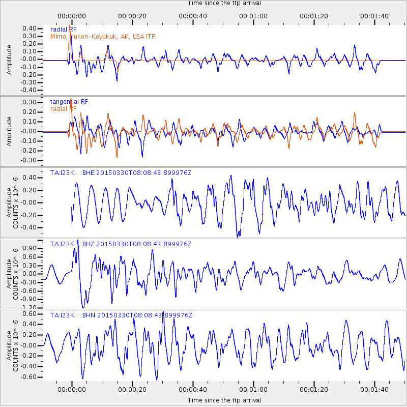
I23K Minto, Yukon-Koyukuk, AK, USA - Earthquake Result Viewer
*The percent match for this event was below the threshold and hence no stack was calculated.
| Earthquake location: |
Tonga Islands |
| Earthquake latitude/longitude: |
-15.4/-173.1 |
| Earthquake time(UTC): |
2015/03/30 (089) 07:56:54 GMT |
| Earthquake Depth: |
10 km |
| Earthquake Magnitude: |
5.6 MB |
| Earthquake Catalog/Contributor: |
NEIC PDE/NEIC COMCAT |
|
| Network: |
TA USArray Transportable Network (new EarthScope stations) |
| Station: |
I23K Minto, Yukon-Koyukuk, AK, USA |
| Lat/Lon: |
65.15 N/149.36 W |
| Elevation: |
149 m |
|
| Distance: |
82.3 deg |
| Az: |
9.882 deg |
| Baz: |
203.057 deg |
| Ray Param: |
$rayparam |
*The percent match for this event was below the threshold and hence was not used in the summary stack. |
|
| Radial Match: |
71.36903 % |
| Radial Bump: |
400 |
| Transverse Match: |
53.90568 % |
| Transverse Bump: |
400 |
| SOD ConfigId: |
7422571 |
| Insert Time: |
2019-04-17 23:54:38.368 +0000 |
| GWidth: |
2.5 |
| Max Bumps: |
400 |
| Tol: |
0.001 |
|
Signal To Noise
| Channel | StoN | STA | LTA |
| TA:I23K: :BHZ:20150330T08:08:43.899976Z | 4.9013658 | 7.346092E-7 | 1.4987847E-7 |
| TA:I23K: :BHN:20150330T08:08:43.899976Z | 2.234911 | 2.8535706E-7 | 1.2768162E-7 |
| TA:I23K: :BHE:20150330T08:08:43.899976Z | 0.90784776 | 1.7400897E-7 | 1.9167199E-7 |
| Arrivals |
| Ps | |
| PpPs | |
| PsPs/PpSs | |


