You are here: Home > Network List > LD - Lamont-Doherty Cooperative Seismographic Network Stations List
> Station HCNY Howe Caverns, Cobleskill, NY > Earthquake Result Viewer
HCNY Howe Caverns, Cobleskill, NY - Earthquake Result Viewer
| Earthquake location: |
Off East Coast Of Honshu, Japan |
| Earthquake latitude/longitude: |
37.1/142.4 |
| Earthquake time(UTC): |
2014/07/11 (192) 19:22:00 GMT |
| Earthquake Depth: |
13 km |
| Earthquake Magnitude: |
6.8 MWP, 6.8 MI |
| Earthquake Catalog/Contributor: |
NEIC PDE/NEIC COMCAT |
|
| Network: |
LD Lamont-Doherty Cooperative Seismographic Network |
| Station: |
HCNY Howe Caverns, Cobleskill, NY |
| Lat/Lon: |
42.70 N/74.40 W |
| Elevation: |
273 m |
|
| Distance: |
93.8 deg |
| Az: |
26.245 deg |
| Baz: |
331.329 deg |
| Ray Param: |
0.041180972 |
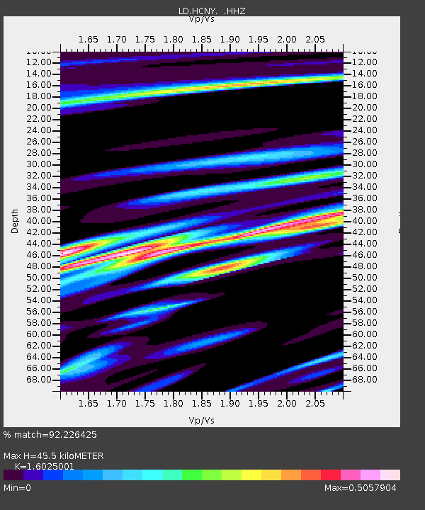
| Estimated Moho Depth: |
45.5 km |
| Estimated Crust Vp/Vs: |
1.60 |
| Assumed Crust Vp: |
6.419 km/s |
| Estimated Crust Vs: |
4.006 km/s |
| Estimated Crust Poisson's Ratio: |
0.18 |
|
| Radial Match: |
92.226425 % |
| Radial Bump: |
400 |
| Transverse Match: |
72.07989 % |
| Transverse Bump: |
400 |
| SOD ConfigId: |
751272 |
| Insert Time: |
2014-07-25 21:23:03.808 +0000 |
| GWidth: |
2.5 |
| Max Bumps: |
400 |
| Tol: |
0.001 |
|

Signal To Noise
| Channel | StoN | STA | LTA |
| LD:HCNY: :HHZ:20140711T19:34:45.48499Z | 9.813156 | 6.216364E-7 | 6.3347244E-8 |
| LD:HCNY: :HHN:20140711T19:34:45.48499Z | 3.090177 | 2.0834732E-7 | 6.742245E-8 |
| LD:HCNY: :HHE:20140711T19:34:45.48499Z | 2.2794938 | 1.14161026E-7 | 5.008174E-8 |
| Arrivals |
| Ps | 4.4 SECOND |
| PpPs | 18 SECOND |
| PsPs/PpSs | 22 SECOND |


