You are here: Home > Network List > LD - Lamont-Doherty Cooperative Seismographic Network Stations List
> Station MMNY Mount Morris Dam, NY > Earthquake Result Viewer
MMNY Mount Morris Dam, NY - Earthquake Result Viewer
| Earthquake location: |
Off East Coast Of Honshu, Japan |
| Earthquake latitude/longitude: |
37.1/142.4 |
| Earthquake time(UTC): |
2014/07/11 (192) 19:22:00 GMT |
| Earthquake Depth: |
13 km |
| Earthquake Magnitude: |
6.8 MWP, 6.8 MI |
| Earthquake Catalog/Contributor: |
NEIC PDE/NEIC COMCAT |
|
| Network: |
LD Lamont-Doherty Cooperative Seismographic Network |
| Station: |
MMNY Mount Morris Dam, NY |
| Lat/Lon: |
42.73 N/77.91 W |
| Elevation: |
241 m |
|
| Distance: |
92.5 deg |
| Az: |
28.472 deg |
| Baz: |
328.834 deg |
| Ray Param: |
0.041442018 |
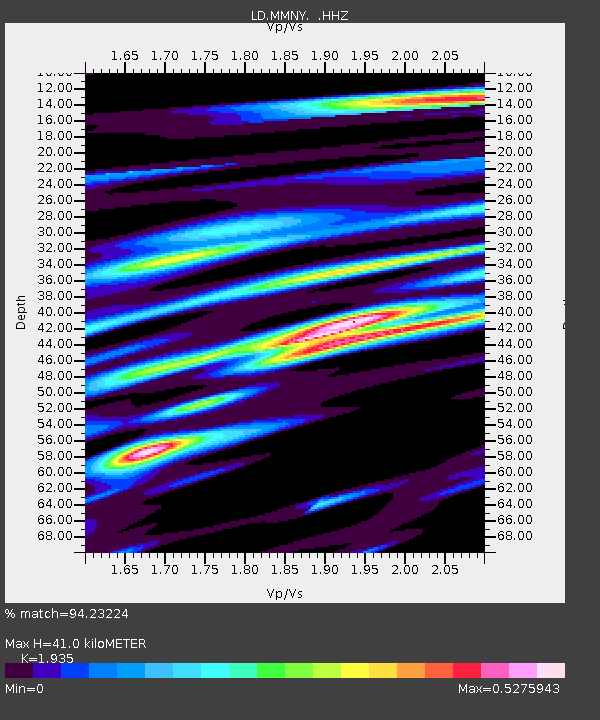
| Estimated Moho Depth: |
41.0 km |
| Estimated Crust Vp/Vs: |
1.93 |
| Assumed Crust Vp: |
6.476 km/s |
| Estimated Crust Vs: |
3.347 km/s |
| Estimated Crust Poisson's Ratio: |
0.32 |
|
| Radial Match: |
94.23224 % |
| Radial Bump: |
344 |
| Transverse Match: |
77.08504 % |
| Transverse Bump: |
400 |
| SOD ConfigId: |
751272 |
| Insert Time: |
2014-07-25 21:23:24.876 +0000 |
| GWidth: |
2.5 |
| Max Bumps: |
400 |
| Tol: |
0.001 |
|

Signal To Noise
| Channel | StoN | STA | LTA |
| LD:MMNY: :HHZ:20140711T19:34:39.445012Z | 9.684145 | 6.304595E-7 | 6.510224E-8 |
| LD:MMNY: :HHN:20140711T19:34:39.445012Z | 2.9679837 | 2.1514924E-7 | 7.249003E-8 |
| LD:MMNY: :HHE:20140711T19:34:39.445012Z | 1.6912163 | 1.02296035E-7 | 6.048666E-8 |
| Arrivals |
| Ps | 6.0 SECOND |
| PpPs | 18 SECOND |
| PsPs/PpSs | 24 SECOND |


