You are here: Home > Network List > N4 - Central and EAstern US Network Stations List
> Station P46A Rosedale, IN, USA > Earthquake Result Viewer
P46A Rosedale, IN, USA - Earthquake Result Viewer
| Earthquake location: |
Off East Coast Of Honshu, Japan |
| Earthquake latitude/longitude: |
37.1/142.4 |
| Earthquake time(UTC): |
2014/07/11 (192) 19:22:00 GMT |
| Earthquake Depth: |
13 km |
| Earthquake Magnitude: |
6.8 MWP, 6.8 MI |
| Earthquake Catalog/Contributor: |
NEIC PDE/NEIC COMCAT |
|
| Network: |
N4 Central and EAstern US Network |
| Station: |
P46A Rosedale, IN, USA |
| Lat/Lon: |
39.62 N/87.21 W |
| Elevation: |
194 m |
|
| Distance: |
91.1 deg |
| Az: |
36.021 deg |
| Baz: |
322.485 deg |
| Ray Param: |
0.04162456 |
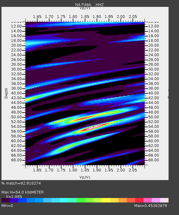
| Estimated Moho Depth: |
54.0 km |
| Estimated Crust Vp/Vs: |
1.88 |
| Assumed Crust Vp: |
6.444 km/s |
| Estimated Crust Vs: |
3.419 km/s |
| Estimated Crust Poisson's Ratio: |
0.30 |
|
| Radial Match: |
92.918274 % |
| Radial Bump: |
359 |
| Transverse Match: |
71.49233 % |
| Transverse Bump: |
400 |
| SOD ConfigId: |
751272 |
| Insert Time: |
2014-07-25 21:28:00.569 +0000 |
| GWidth: |
2.5 |
| Max Bumps: |
400 |
| Tol: |
0.001 |
|

Signal To Noise
| Channel | StoN | STA | LTA |
| N4:P46A: :HHZ:20140711T19:34:32.989995Z | 10.682966 | 8.0070305E-7 | 7.495138E-8 |
| N4:P46A: :HHN:20140711T19:34:32.989995Z | 2.3033857 | 2.1038451E-7 | 9.133707E-8 |
| N4:P46A: :HHE:20140711T19:34:32.989995Z | 2.0928829 | 1.8274433E-7 | 8.7317034E-8 |
| Arrivals |
| Ps | 7.6 SECOND |
| PpPs | 24 SECOND |
| PsPs/PpSs | 31 SECOND |


