You are here: Home > Network List > N4 - Central and EAstern US Network Stations List
> Station B35B Bob, Littlefork, MN, USA > Earthquake Result Viewer
B35B Bob, Littlefork, MN, USA - Earthquake Result Viewer
| Earthquake location: |
Off East Coast Of Honshu, Japan |
| Earthquake latitude/longitude: |
37.1/142.4 |
| Earthquake time(UTC): |
2014/07/11 (192) 19:22:00 GMT |
| Earthquake Depth: |
13 km |
| Earthquake Magnitude: |
6.8 MWP, 6.8 MI |
| Earthquake Catalog/Contributor: |
NEIC PDE/NEIC COMCAT |
|
| Network: |
N4 Central and EAstern US Network |
| Station: |
B35B Bob, Littlefork, MN, USA |
| Lat/Lon: |
48.36 N/93.73 W |
| Elevation: |
354 m |
|
| Distance: |
81.4 deg |
| Az: |
34.042 deg |
| Baz: |
317.828 deg |
| Ray Param: |
0.047610585 |
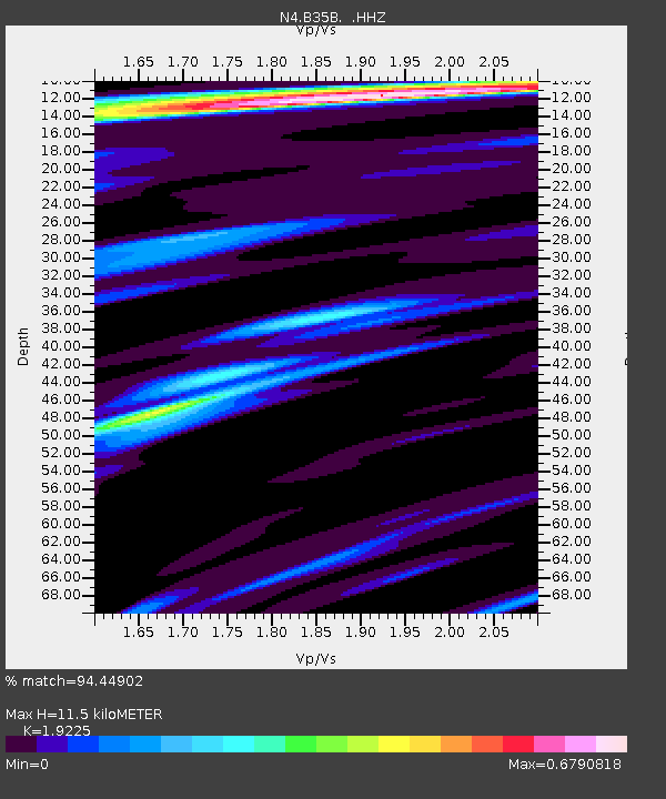
| Estimated Moho Depth: |
11.5 km |
| Estimated Crust Vp/Vs: |
1.92 |
| Assumed Crust Vp: |
6.419 km/s |
| Estimated Crust Vs: |
3.339 km/s |
| Estimated Crust Poisson's Ratio: |
0.31 |
|
| Radial Match: |
94.44902 % |
| Radial Bump: |
386 |
| Transverse Match: |
78.63862 % |
| Transverse Bump: |
400 |
| SOD ConfigId: |
751272 |
| Insert Time: |
2014-07-25 21:30:19.961 +0000 |
| GWidth: |
2.5 |
| Max Bumps: |
400 |
| Tol: |
0.001 |
|

Signal To Noise
| Channel | StoN | STA | LTA |
| N4:B35B: :HHZ:20140711T19:33:45.279973Z | 23.528711 | 1.4082233E-6 | 5.9851274E-8 |
| N4:B35B: :HHN:20140711T19:33:45.279973Z | 6.272797 | 3.7083555E-7 | 5.9118054E-8 |
| N4:B35B: :HHE:20140711T19:33:45.279973Z | 4.933027 | 3.6282577E-7 | 7.355033E-8 |
| Arrivals |
| Ps | 1.7 SECOND |
| PpPs | 5.1 SECOND |
| PsPs/PpSs | 6.8 SECOND |


