You are here: Home > Network List > AU - Australian Seismological Centre Stations List
> Station WRKA Warrakurna, Western Australia > Earthquake Result Viewer
WRKA Warrakurna, Western Australia - Earthquake Result Viewer
| Earthquake location: |
Samoa Islands Region |
| Earthquake latitude/longitude: |
-15.4/-172.9 |
| Earthquake time(UTC): |
2015/03/30 (089) 08:18:00 GMT |
| Earthquake Depth: |
10 km |
| Earthquake Magnitude: |
6.8 MWP, 6.8 MI |
| Earthquake Catalog/Contributor: |
NEIC PDE/NEIC COMCAT |
|
| Network: |
AU Australian Seismological Centre |
| Station: |
WRKA Warrakurna, Western Australia |
| Lat/Lon: |
25.04 S/128.30 E |
| Elevation: |
622 m |
|
| Distance: |
55.6 deg |
| Az: |
250.037 deg |
| Baz: |
92.028 deg |
| Ray Param: |
0.06466664 |
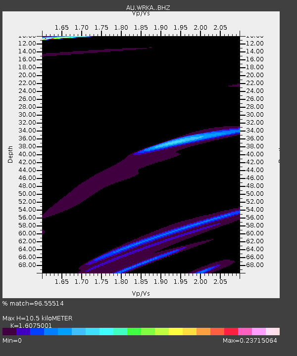
| Estimated Moho Depth: |
10.5 km |
| Estimated Crust Vp/Vs: |
1.61 |
| Assumed Crust Vp: |
6.51 km/s |
| Estimated Crust Vs: |
4.05 km/s |
| Estimated Crust Poisson's Ratio: |
0.18 |
|
| Radial Match: |
96.55514 % |
| Radial Bump: |
290 |
| Transverse Match: |
69.811935 % |
| Transverse Bump: |
400 |
| SOD ConfigId: |
7422571 |
| Insert Time: |
2019-04-17 23:57:39.799 +0000 |
| GWidth: |
2.5 |
| Max Bumps: |
400 |
| Tol: |
0.001 |
|

Signal To Noise
| Channel | StoN | STA | LTA |
| AU:WRKA: :BHZ:20150330T08:27:06.068984Z | 2.4742615 | 2.1923306E-6 | 8.860545E-7 |
| AU:WRKA: :BHN:20150330T08:27:06.068984Z | 1.620124 | 1.6046965E-6 | 9.904776E-7 |
| AU:WRKA: :BHE:20150330T08:27:06.068984Z | 1.218352 | 1.0142024E-6 | 8.32438E-7 |
| Arrivals |
| Ps | 1.0 SECOND |
| PpPs | 4.0 SECOND |
| PsPs/PpSs | 5.0 SECOND |


