You are here: Home > Network List > TA - USArray Transportable Network (new EarthScope stations) Stations List
> Station 109C Camp Elliot, Mirimar, CA, USA > Earthquake Result Viewer
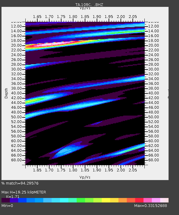
109C Camp Elliot, Mirimar, CA, USA - Earthquake Result Viewer
| Earthquake location: |
Off East Coast Of Honshu, Japan |
| Earthquake latitude/longitude: |
37.1/142.4 |
| Earthquake time(UTC): |
2014/07/11 (192) 19:22:00 GMT |
| Earthquake Depth: |
13 km |
| Earthquake Magnitude: |
6.8 MWP, 6.8 MI |
| Earthquake Catalog/Contributor: |
NEIC PDE/NEIC COMCAT |
|
| Network: |
TA USArray Transportable Network (new EarthScope stations) |
| Station: |
109C Camp Elliot, Mirimar, CA, USA |
| Lat/Lon: |
32.89 N/117.11 W |
| Elevation: |
150 m |
|
| Distance: |
78.4 deg |
| Az: |
57.62 deg |
| Baz: |
306.599 deg |
| Ray Param: |
0.049673147 |
| Estimated Moho Depth: |
19.25 km |
| Estimated Crust Vp/Vs: |
1.71 |
| Assumed Crust Vp: |
6.264 km/s |
| Estimated Crust Vs: |
3.663 km/s |
| Estimated Crust Poisson's Ratio: |
0.24 |
|
| Radial Match: |
94.29576 % |
| Radial Bump: |
316 |
| Transverse Match: |
80.31163 % |
| Transverse Bump: |
400 |
| SOD ConfigId: |
751272 |
| Insert Time: |
2014-07-25 21:40:18.514 +0000 |
| GWidth: |
2.5 |
| Max Bumps: |
400 |
| Tol: |
0.001 |
|

Signal To Noise
| Channel | StoN | STA | LTA |
| TA:109C: :BHZ:20140711T19:33:29.018987Z | 3.297665 | 3.89756E-7 | 1.181915E-7 |
| TA:109C: :BHN:20140711T19:33:29.018987Z | 1.3374448 | 1.6935934E-7 | 1.2662903E-7 |
| TA:109C: :BHE:20140711T19:33:29.018987Z | 1.2296989 | 1.5196402E-7 | 1.2357825E-7 |
| Arrivals |
| Ps | 2.2 SECOND |
| PpPs | 8.1 SECOND |
| PsPs/PpSs | 10 SECOND |


