You are here: Home > Network List > TA - USArray Transportable Network (new EarthScope stations) Stations List
> Station A36M Sachs Harbour, NT, CAN > Earthquake Result Viewer
A36M Sachs Harbour, NT, CAN - Earthquake Result Viewer
| Earthquake location: |
Off East Coast Of Honshu, Japan |
| Earthquake latitude/longitude: |
37.1/142.4 |
| Earthquake time(UTC): |
2014/07/11 (192) 19:22:00 GMT |
| Earthquake Depth: |
13 km |
| Earthquake Magnitude: |
6.8 MWP, 6.8 MI |
| Earthquake Catalog/Contributor: |
NEIC PDE/NEIC COMCAT |
|
| Network: |
TA USArray Transportable Network (new EarthScope stations) |
| Station: |
A36M Sachs Harbour, NT, CAN |
| Lat/Lon: |
71.99 N/125.25 W |
| Elevation: |
32 m |
|
| Distance: |
55.9 deg |
| Az: |
22.037 deg |
| Baz: |
285.286 deg |
| Ray Param: |
0.06445764 |
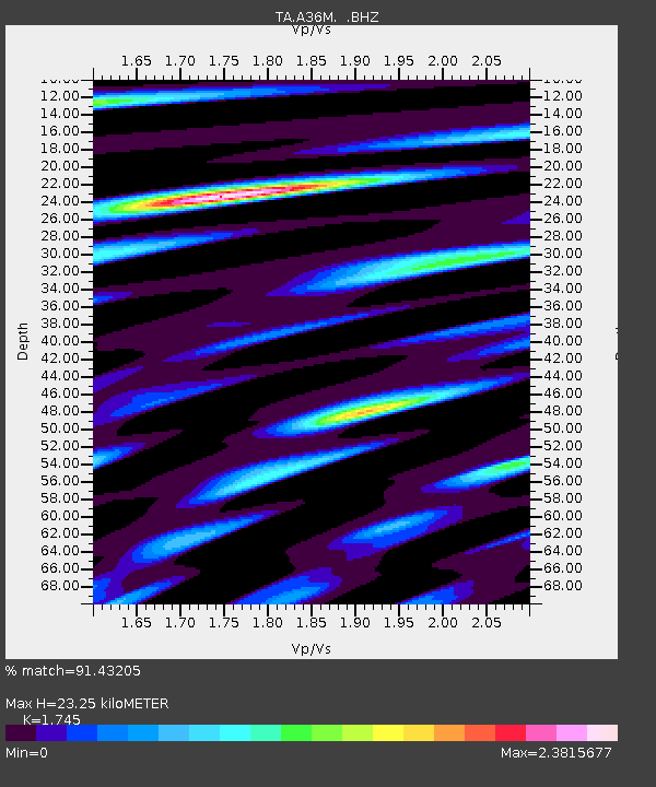
| Estimated Moho Depth: |
23.25 km |
| Estimated Crust Vp/Vs: |
1.75 |
| Assumed Crust Vp: |
6.24 km/s |
| Estimated Crust Vs: |
3.576 km/s |
| Estimated Crust Poisson's Ratio: |
0.26 |
|
| Radial Match: |
91.43205 % |
| Radial Bump: |
400 |
| Transverse Match: |
86.364365 % |
| Transverse Bump: |
400 |
| SOD ConfigId: |
751272 |
| Insert Time: |
2014-07-25 21:40:41.886 +0000 |
| GWidth: |
2.5 |
| Max Bumps: |
400 |
| Tol: |
0.001 |
|
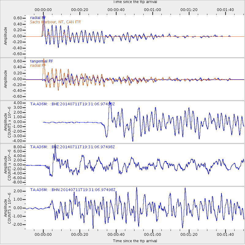
Signal To Noise
| Channel | StoN | STA | LTA |
| TA:A36M: :BHZ:20140711T19:31:06.97498Z | 37.09955 | 2.23399E-6 | 6.0216095E-8 |
| TA:A36M: :BHN:20140711T19:31:06.97498Z | 5.512018 | 3.007453E-7 | 5.4561742E-8 |
| TA:A36M: :BHE:20140711T19:31:06.97498Z | 19.959164 | 1.0846442E-6 | 5.434317E-8 |
| Arrivals |
| Ps | 2.9 SECOND |
| PpPs | 9.7 SECOND |
| PsPs/PpSs | 13 SECOND |


