You are here: Home > Network List > TA - USArray Transportable Network (new EarthScope stations) Stations List
> Station E53A Dumoine, Pontiac MRC, QC, CAN > Earthquake Result Viewer
E53A Dumoine, Pontiac MRC, QC, CAN - Earthquake Result Viewer
| Earthquake location: |
Off East Coast Of Honshu, Japan |
| Earthquake latitude/longitude: |
37.1/142.4 |
| Earthquake time(UTC): |
2014/07/11 (192) 19:22:00 GMT |
| Earthquake Depth: |
13 km |
| Earthquake Magnitude: |
6.8 MWP, 6.8 MI |
| Earthquake Catalog/Contributor: |
NEIC PDE/NEIC COMCAT |
|
| Network: |
TA USArray Transportable Network (new EarthScope stations) |
| Station: |
E53A Dumoine, Pontiac MRC, QC, CAN |
| Lat/Lon: |
46.38 N/77.66 W |
| Elevation: |
355 m |
|
| Distance: |
89.5 deg |
| Az: |
26.442 deg |
| Baz: |
329.039 deg |
| Ray Param: |
0.04181407 |
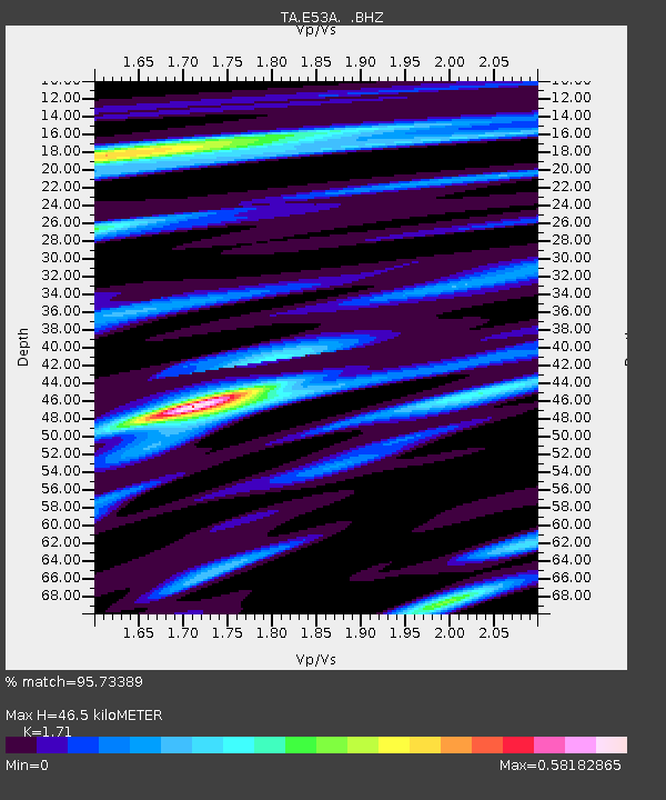
| Estimated Moho Depth: |
46.5 km |
| Estimated Crust Vp/Vs: |
1.71 |
| Assumed Crust Vp: |
6.622 km/s |
| Estimated Crust Vs: |
3.873 km/s |
| Estimated Crust Poisson's Ratio: |
0.24 |
|
| Radial Match: |
95.73389 % |
| Radial Bump: |
343 |
| Transverse Match: |
85.0204 % |
| Transverse Bump: |
400 |
| SOD ConfigId: |
751272 |
| Insert Time: |
2014-07-25 21:42:39.852 +0000 |
| GWidth: |
2.5 |
| Max Bumps: |
400 |
| Tol: |
0.001 |
|

Signal To Noise
| Channel | StoN | STA | LTA |
| TA:E53A: :BHZ:20140711T19:34:25.424993Z | 16.538475 | 1.0882837E-6 | 6.580315E-8 |
| TA:E53A: :BHN:20140711T19:34:25.424993Z | 6.220295 | 2.8526236E-7 | 4.585994E-8 |
| TA:E53A: :BHE:20140711T19:34:25.424993Z | 6.792236 | 2.1713035E-7 | 3.196743E-8 |
| Arrivals |
| Ps | 5.1 SECOND |
| PpPs | 19 SECOND |
| PsPs/PpSs | 24 SECOND |


