You are here: Home > Network List > TA - USArray Transportable Network (new EarthScope stations) Stations List
> Station E54A Lac Daplat, Pontiac, MRC, QC, CAN > Earthquake Result Viewer
E54A Lac Daplat, Pontiac, MRC, QC, CAN - Earthquake Result Viewer
| Earthquake location: |
Off East Coast Of Honshu, Japan |
| Earthquake latitude/longitude: |
37.1/142.4 |
| Earthquake time(UTC): |
2014/07/11 (192) 19:22:00 GMT |
| Earthquake Depth: |
13 km |
| Earthquake Magnitude: |
6.8 MWP, 6.8 MI |
| Earthquake Catalog/Contributor: |
NEIC PDE/NEIC COMCAT |
|
| Network: |
TA USArray Transportable Network (new EarthScope stations) |
| Station: |
E54A Lac Daplat, Pontiac, MRC, QC, CAN |
| Lat/Lon: |
46.43 N/77.19 W |
| Elevation: |
277 m |
|
| Distance: |
89.6 deg |
| Az: |
26.13 deg |
| Baz: |
329.381 deg |
| Ray Param: |
0.041732527 |
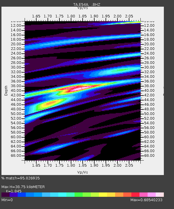
| Estimated Moho Depth: |
38.75 km |
| Estimated Crust Vp/Vs: |
1.85 |
| Assumed Crust Vp: |
6.622 km/s |
| Estimated Crust Vs: |
3.589 km/s |
| Estimated Crust Poisson's Ratio: |
0.29 |
|
| Radial Match: |
95.826935 % |
| Radial Bump: |
351 |
| Transverse Match: |
84.92025 % |
| Transverse Bump: |
400 |
| SOD ConfigId: |
751272 |
| Insert Time: |
2014-07-25 21:42:42.332 +0000 |
| GWidth: |
2.5 |
| Max Bumps: |
400 |
| Tol: |
0.001 |
|
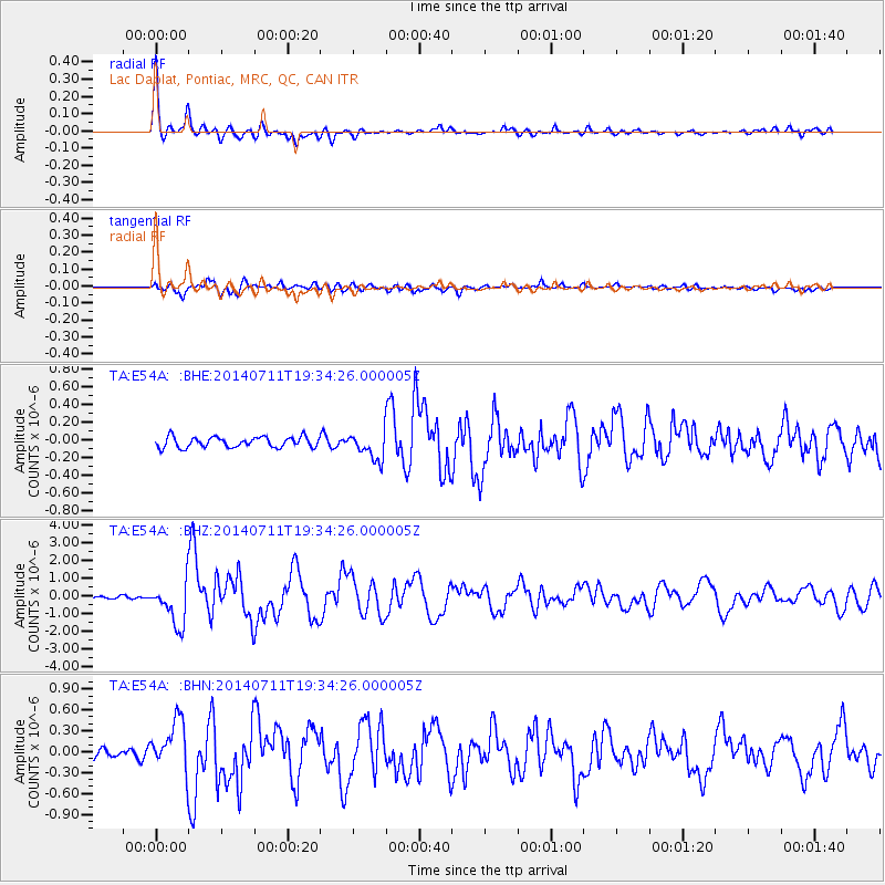
Signal To Noise
| Channel | StoN | STA | LTA |
| TA:E54A: :BHZ:20140711T19:34:26.000005Z | 19.551336 | 1.221935E-6 | 6.24988E-8 |
| TA:E54A: :BHN:20140711T19:34:26.000005Z | 7.020941 | 3.5337894E-7 | 5.0332133E-8 |
| TA:E54A: :BHE:20140711T19:34:26.000005Z | 2.5567236 | 1.5127223E-7 | 5.9166442E-8 |
| Arrivals |
| Ps | 5.1 SECOND |
| PpPs | 16 SECOND |
| PsPs/PpSs | 21 SECOND |


