You are here: Home > Network List > TA - USArray Transportable Network (new EarthScope stations) Stations List
> Station E56A St. Veronique, QC, CAN > Earthquake Result Viewer
E56A St. Veronique, QC, CAN - Earthquake Result Viewer
| Earthquake location: |
Off East Coast Of Honshu, Japan |
| Earthquake latitude/longitude: |
37.1/142.4 |
| Earthquake time(UTC): |
2014/07/11 (192) 19:22:00 GMT |
| Earthquake Depth: |
13 km |
| Earthquake Magnitude: |
6.8 MWP, 6.8 MI |
| Earthquake Catalog/Contributor: |
NEIC PDE/NEIC COMCAT |
|
| Network: |
TA USArray Transportable Network (new EarthScope stations) |
| Station: |
E56A St. Veronique, QC, CAN |
| Lat/Lon: |
46.54 N/75.03 W |
| Elevation: |
320 m |
|
| Distance: |
90.2 deg |
| Az: |
24.785 deg |
| Baz: |
330.936 deg |
| Ray Param: |
0.041686527 |
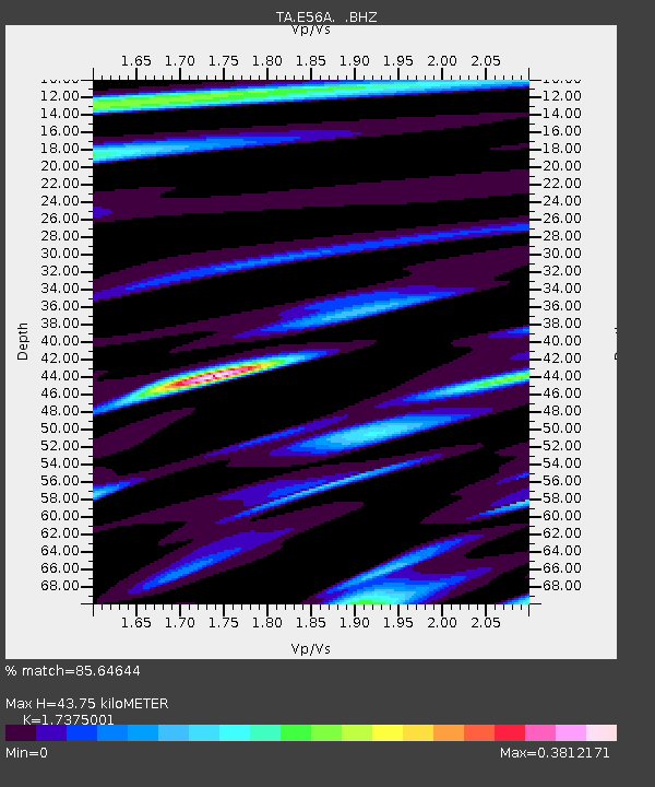
| Estimated Moho Depth: |
43.75 km |
| Estimated Crust Vp/Vs: |
1.74 |
| Assumed Crust Vp: |
6.61 km/s |
| Estimated Crust Vs: |
3.804 km/s |
| Estimated Crust Poisson's Ratio: |
0.25 |
|
| Radial Match: |
85.64644 % |
| Radial Bump: |
382 |
| Transverse Match: |
61.95494 % |
| Transverse Bump: |
400 |
| SOD ConfigId: |
751272 |
| Insert Time: |
2014-07-25 21:42:50.601 +0000 |
| GWidth: |
2.5 |
| Max Bumps: |
400 |
| Tol: |
0.001 |
|

Signal To Noise
| Channel | StoN | STA | LTA |
| TA:E56A: :BHZ:20140711T19:34:28.97498Z | 16.408617 | 1.2777379E-6 | 7.786993E-8 |
| TA:E56A: :BHN:20140711T19:34:28.97498Z | 1.7723836 | 3.3433147E-7 | 1.886338E-7 |
| TA:E56A: :BHE:20140711T19:34:28.97498Z | 2.343581 | 2.3047969E-7 | 9.834509E-8 |
| Arrivals |
| Ps | 5.0 SECOND |
| PpPs | 18 SECOND |
| PsPs/PpSs | 23 SECOND |


