You are here: Home > Network List > TA - USArray Transportable Network (new EarthScope stations) Stations List
> Station E60A Ste Agathe de Lotbiniere, QC, CAN > Earthquake Result Viewer
E60A Ste Agathe de Lotbiniere, QC, CAN - Earthquake Result Viewer
| Earthquake location: |
Off East Coast Of Honshu, Japan |
| Earthquake latitude/longitude: |
37.1/142.4 |
| Earthquake time(UTC): |
2014/07/11 (192) 19:22:00 GMT |
| Earthquake Depth: |
13 km |
| Earthquake Magnitude: |
6.8 MWP, 6.8 MI |
| Earthquake Catalog/Contributor: |
NEIC PDE/NEIC COMCAT |
|
| Network: |
TA USArray Transportable Network (new EarthScope stations) |
| Station: |
E60A Ste Agathe de Lotbiniere, QC, CAN |
| Lat/Lon: |
46.37 N/71.45 W |
| Elevation: |
181 m |
|
| Distance: |
91.6 deg |
| Az: |
22.672 deg |
| Baz: |
333.561 deg |
| Ray Param: |
0.04159081 |
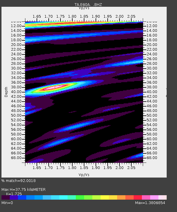
| Estimated Moho Depth: |
37.75 km |
| Estimated Crust Vp/Vs: |
1.73 |
| Assumed Crust Vp: |
6.61 km/s |
| Estimated Crust Vs: |
3.832 km/s |
| Estimated Crust Poisson's Ratio: |
0.25 |
|
| Radial Match: |
92.0018 % |
| Radial Bump: |
400 |
| Transverse Match: |
63.6585 % |
| Transverse Bump: |
400 |
| SOD ConfigId: |
751272 |
| Insert Time: |
2014-07-25 21:43:05.810 +0000 |
| GWidth: |
2.5 |
| Max Bumps: |
400 |
| Tol: |
0.001 |
|
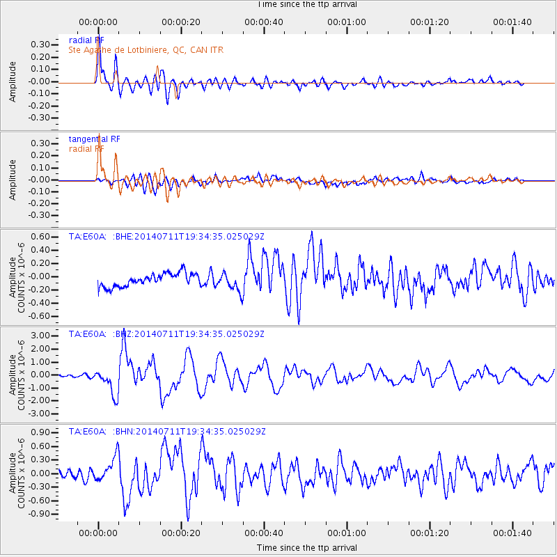
Signal To Noise
| Channel | StoN | STA | LTA |
| TA:E60A: :BHZ:20140711T19:34:35.025029Z | 13.22731 | 1.0760926E-6 | 8.135385E-8 |
| TA:E60A: :BHN:20140711T19:34:35.025029Z | 3.7021434 | 3.060422E-7 | 8.266622E-8 |
| TA:E60A: :BHE:20140711T19:34:35.025029Z | 1.4303493 | 1.4161236E-7 | 9.900543E-8 |
| Arrivals |
| Ps | 4.2 SECOND |
| PpPs | 15 SECOND |
| PsPs/PpSs | 19 SECOND |


