You are here: Home > Network List > TA - USArray Transportable Network (new EarthScope stations) Stations List
> Station J05D Fort Rock, OR, USA > Earthquake Result Viewer
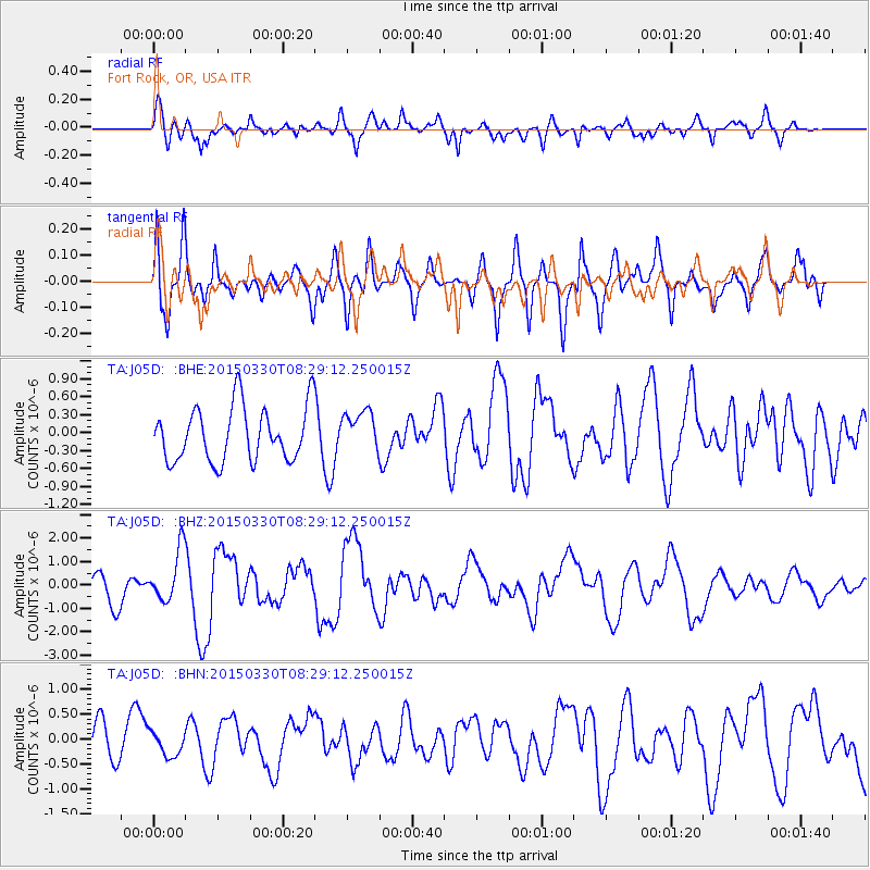
J05D Fort Rock, OR, USA - Earthquake Result Viewer
*The percent match for this event was below the threshold and hence no stack was calculated.
| Earthquake location: |
Samoa Islands Region |
| Earthquake latitude/longitude: |
-15.4/-172.9 |
| Earthquake time(UTC): |
2015/03/30 (089) 08:18:00 GMT |
| Earthquake Depth: |
10 km |
| Earthquake Magnitude: |
6.8 MWP, 6.8 MI |
| Earthquake Catalog/Contributor: |
NEIC PDE/NEIC COMCAT |
|
| Network: |
TA USArray Transportable Network (new EarthScope stations) |
| Station: |
J05D Fort Rock, OR, USA |
| Lat/Lon: |
43.28 N/121.23 W |
| Elevation: |
1541 m |
|
| Distance: |
75.1 deg |
| Az: |
36.35 deg |
| Baz: |
231.522 deg |
| Ray Param: |
$rayparam |
*The percent match for this event was below the threshold and hence was not used in the summary stack. |
|
| Radial Match: |
73.76329 % |
| Radial Bump: |
400 |
| Transverse Match: |
58.60619 % |
| Transverse Bump: |
400 |
| SOD ConfigId: |
7422571 |
| Insert Time: |
2019-04-18 00:01:46.218 +0000 |
| GWidth: |
2.5 |
| Max Bumps: |
400 |
| Tol: |
0.001 |
|
Signal To Noise
| Channel | StoN | STA | LTA |
| TA:J05D: :BHZ:20150330T08:29:12.250015Z | 1.7499523 | 1.1337012E-6 | 6.478469E-7 |
| TA:J05D: :BHN:20150330T08:29:12.250015Z | 0.48629436 | 2.28971E-7 | 4.7084856E-7 |
| TA:J05D: :BHE:20150330T08:29:12.250015Z | 0.8054792 | 3.5302634E-7 | 4.3828112E-7 |
| Arrivals |
| Ps | |
| PpPs | |
| PsPs/PpSs | |


