You are here: Home > Network List > TA - USArray Transportable Network (new EarthScope stations) Stations List
> Station G46A Petoskey, MI, USA > Earthquake Result Viewer
G46A Petoskey, MI, USA - Earthquake Result Viewer
| Earthquake location: |
Off East Coast Of Honshu, Japan |
| Earthquake latitude/longitude: |
37.1/142.4 |
| Earthquake time(UTC): |
2014/07/11 (192) 19:22:00 GMT |
| Earthquake Depth: |
13 km |
| Earthquake Magnitude: |
6.8 MWP, 6.8 MI |
| Earthquake Catalog/Contributor: |
NEIC PDE/NEIC COMCAT |
|
| Network: |
TA USArray Transportable Network (new EarthScope stations) |
| Station: |
G46A Petoskey, MI, USA |
| Lat/Lon: |
45.32 N/84.86 W |
| Elevation: |
239 m |
|
| Distance: |
87.6 deg |
| Az: |
31.223 deg |
| Baz: |
324.01 deg |
| Ray Param: |
0.04321267 |
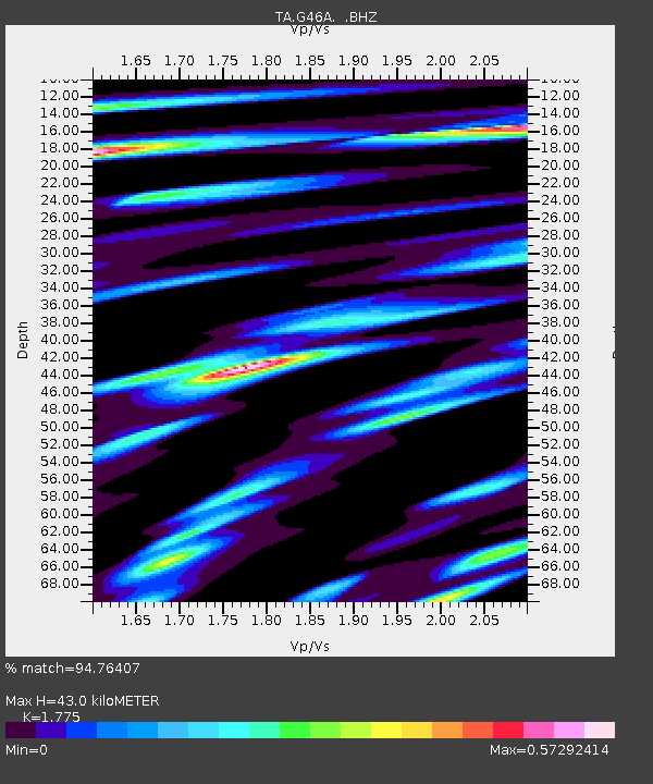
| Estimated Moho Depth: |
43.0 km |
| Estimated Crust Vp/Vs: |
1.77 |
| Assumed Crust Vp: |
6.483 km/s |
| Estimated Crust Vs: |
3.652 km/s |
| Estimated Crust Poisson's Ratio: |
0.27 |
|
| Radial Match: |
94.76407 % |
| Radial Bump: |
400 |
| Transverse Match: |
82.80111 % |
| Transverse Bump: |
400 |
| SOD ConfigId: |
751272 |
| Insert Time: |
2014-07-25 21:44:52.932 +0000 |
| GWidth: |
2.5 |
| Max Bumps: |
400 |
| Tol: |
0.001 |
|

Signal To Noise
| Channel | StoN | STA | LTA |
| TA:G46A: :BHZ:20140711T19:34:16.500005Z | 14.211259 | 1.4341693E-6 | 1.0091783E-7 |
| TA:G46A: :BHN:20140711T19:34:16.500005Z | 3.1774418 | 5.271808E-7 | 1.659136E-7 |
| TA:G46A: :BHE:20140711T19:34:16.500005Z | 1.9425157 | 3.1435957E-7 | 1.6183115E-7 |
| Arrivals |
| Ps | 5.3 SECOND |
| PpPs | 18 SECOND |
| PsPs/PpSs | 23 SECOND |


