You are here: Home > Network List > TA - USArray Transportable Network (new EarthScope stations) Stations List
> Station G53A Haliburton, ON, CAN > Earthquake Result Viewer
G53A Haliburton, ON, CAN - Earthquake Result Viewer
| Earthquake location: |
Off East Coast Of Honshu, Japan |
| Earthquake latitude/longitude: |
37.1/142.4 |
| Earthquake time(UTC): |
2014/07/11 (192) 19:22:00 GMT |
| Earthquake Depth: |
13 km |
| Earthquake Magnitude: |
6.8 MWP, 6.8 MI |
| Earthquake Catalog/Contributor: |
NEIC PDE/NEIC COMCAT |
|
| Network: |
TA USArray Transportable Network (new EarthScope stations) |
| Station: |
G53A Haliburton, ON, CAN |
| Lat/Lon: |
45.12 N/78.62 W |
| Elevation: |
333 m |
|
| Distance: |
90.2 deg |
| Az: |
27.669 deg |
| Baz: |
328.357 deg |
| Ray Param: |
0.041689515 |
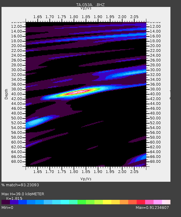
| Estimated Moho Depth: |
39.0 km |
| Estimated Crust Vp/Vs: |
1.82 |
| Assumed Crust Vp: |
6.577 km/s |
| Estimated Crust Vs: |
3.624 km/s |
| Estimated Crust Poisson's Ratio: |
0.28 |
|
| Radial Match: |
93.23093 % |
| Radial Bump: |
400 |
| Transverse Match: |
78.80434 % |
| Transverse Bump: |
400 |
| SOD ConfigId: |
751272 |
| Insert Time: |
2014-07-25 21:45:00.673 +0000 |
| GWidth: |
2.5 |
| Max Bumps: |
400 |
| Tol: |
0.001 |
|

Signal To Noise
| Channel | StoN | STA | LTA |
| TA:G53A: :BHZ:20140711T19:34:28.775029Z | 11.63878 | 1.0248966E-6 | 8.8058776E-8 |
| TA:G53A: :BHN:20140711T19:34:28.775029Z | 5.153863 | 3.323483E-7 | 6.4485285E-8 |
| TA:G53A: :BHE:20140711T19:34:28.775029Z | 3.743942 | 2.53758E-7 | 6.7778295E-8 |
| Arrivals |
| Ps | 4.9 SECOND |
| PpPs | 16 SECOND |
| PsPs/PpSs | 21 SECOND |


