You are here: Home > Network List > TA - USArray Transportable Network (new EarthScope stations) Stations List
> Station G57A Newington, ON, CAN > Earthquake Result Viewer
G57A Newington, ON, CAN - Earthquake Result Viewer
| Earthquake location: |
Off East Coast Of Honshu, Japan |
| Earthquake latitude/longitude: |
37.1/142.4 |
| Earthquake time(UTC): |
2014/07/11 (192) 19:22:00 GMT |
| Earthquake Depth: |
13 km |
| Earthquake Magnitude: |
6.8 MWP, 6.8 MI |
| Earthquake Catalog/Contributor: |
NEIC PDE/NEIC COMCAT |
|
| Network: |
TA USArray Transportable Network (new EarthScope stations) |
| Station: |
G57A Newington, ON, CAN |
| Lat/Lon: |
45.10 N/74.99 W |
| Elevation: |
96 m |
|
| Distance: |
91.5 deg |
| Az: |
25.455 deg |
| Baz: |
330.96 deg |
| Ray Param: |
0.041595552 |
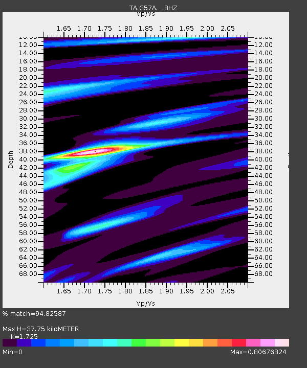
| Estimated Moho Depth: |
37.75 km |
| Estimated Crust Vp/Vs: |
1.73 |
| Assumed Crust Vp: |
6.419 km/s |
| Estimated Crust Vs: |
3.721 km/s |
| Estimated Crust Poisson's Ratio: |
0.25 |
|
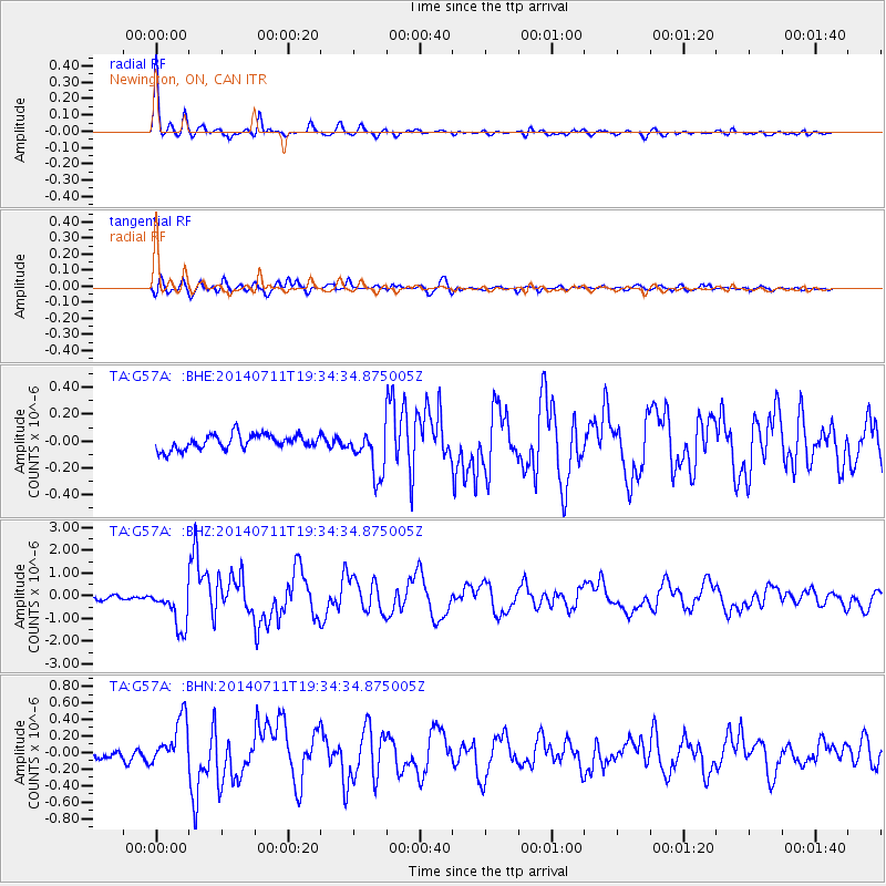
| Radial Match: |
94.82587 % |
| Radial Bump: |
274 |
| Transverse Match: |
83.43414 % |
| Transverse Bump: |
400 |
| SOD ConfigId: |
751272 |
| Insert Time: |
2014-07-25 21:45:12.936 +0000 |
| GWidth: |
2.5 |
| Max Bumps: |
400 |
| Tol: |
0.001 |
|
Signal To Noise
| Channel | StoN | STA | LTA |
| TA:G57A: :BHZ:20140711T19:34:34.875005Z | 11.364311 | 9.066397E-7 | 7.9779554E-8 |
| TA:G57A: :BHN:20140711T19:34:34.875005Z | 4.647016 | 2.807963E-7 | 6.042508E-8 |
| TA:G57A: :BHE:20140711T19:34:34.875005Z | 3.1441662 | 1.7208791E-7 | 5.4732443E-8 |
| Arrivals |
| Ps | 4.4 SECOND |
| PpPs | 16 SECOND |
| PsPs/PpSs | 20 SECOND |


