You are here: Home > Network List > TA - USArray Transportable Network (new EarthScope stations) Stations List
> Station H52A Wyevale, ON, CAN > Earthquake Result Viewer
H52A Wyevale, ON, CAN - Earthquake Result Viewer
| Earthquake location: |
Off East Coast Of Honshu, Japan |
| Earthquake latitude/longitude: |
37.1/142.4 |
| Earthquake time(UTC): |
2014/07/11 (192) 19:22:00 GMT |
| Earthquake Depth: |
13 km |
| Earthquake Magnitude: |
6.8 MWP, 6.8 MI |
| Earthquake Catalog/Contributor: |
NEIC PDE/NEIC COMCAT |
|
| Network: |
TA USArray Transportable Network (new EarthScope stations) |
| Station: |
H52A Wyevale, ON, CAN |
| Lat/Lon: |
44.64 N/79.89 W |
| Elevation: |
209 m |
|
| Distance: |
90.1 deg |
| Az: |
28.686 deg |
| Baz: |
327.464 deg |
| Ray Param: |
0.041694593 |
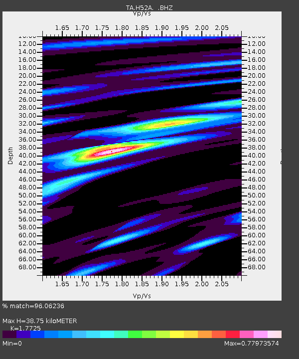
| Estimated Moho Depth: |
38.75 km |
| Estimated Crust Vp/Vs: |
1.77 |
| Assumed Crust Vp: |
6.577 km/s |
| Estimated Crust Vs: |
3.711 km/s |
| Estimated Crust Poisson's Ratio: |
0.27 |
|
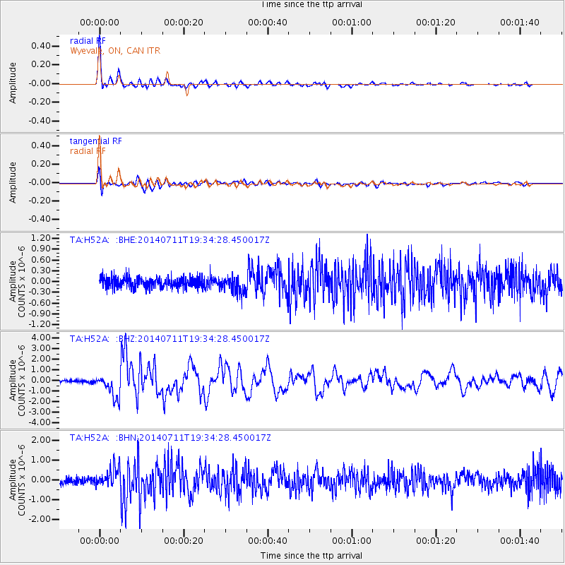
| Radial Match: |
96.06236 % |
| Radial Bump: |
400 |
| Transverse Match: |
88.15307 % |
| Transverse Bump: |
400 |
| SOD ConfigId: |
751272 |
| Insert Time: |
2014-07-25 21:45:51.210 +0000 |
| GWidth: |
2.5 |
| Max Bumps: |
400 |
| Tol: |
0.001 |
|
Signal To Noise
| Channel | StoN | STA | LTA |
| TA:H52A: :BHZ:20140711T19:34:28.450017Z | 13.096547 | 1.1382438E-6 | 8.691174E-8 |
| TA:H52A: :BHN:20140711T19:34:28.450017Z | 3.4232771 | 4.9147286E-7 | 1.4356795E-7 |
| TA:H52A: :BHE:20140711T19:34:28.450017Z | 1.6283298 | 2.3262604E-7 | 1.4286175E-7 |
| Arrivals |
| Ps | 4.7 SECOND |
| PpPs | 16 SECOND |
| PsPs/PpSs | 21 SECOND |


