You are here: Home > Network List > TA - USArray Transportable Network (new EarthScope stations) Stations List
> Station H64A Troy, ME, USA > Earthquake Result Viewer
H64A Troy, ME, USA - Earthquake Result Viewer
| Earthquake location: |
Off East Coast Of Honshu, Japan |
| Earthquake latitude/longitude: |
37.1/142.4 |
| Earthquake time(UTC): |
2014/07/11 (192) 19:22:00 GMT |
| Earthquake Depth: |
13 km |
| Earthquake Magnitude: |
6.8 MWP, 6.8 MI |
| Earthquake Catalog/Contributor: |
NEIC PDE/NEIC COMCAT |
|
| Network: |
TA USArray Transportable Network (new EarthScope stations) |
| Station: |
H64A Troy, ME, USA |
| Lat/Lon: |
44.64 N/69.22 W |
| Elevation: |
158 m |
|
| Distance: |
93.8 deg |
| Az: |
22.007 deg |
| Baz: |
335.175 deg |
| Ray Param: |
0.041189555 |
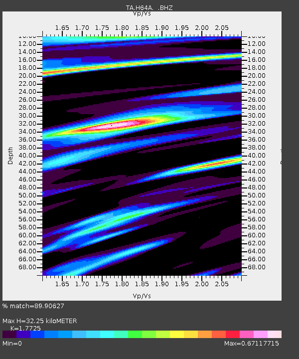
| Estimated Moho Depth: |
32.25 km |
| Estimated Crust Vp/Vs: |
1.77 |
| Assumed Crust Vp: |
6.419 km/s |
| Estimated Crust Vs: |
3.622 km/s |
| Estimated Crust Poisson's Ratio: |
0.27 |
|
| Radial Match: |
89.90627 % |
| Radial Bump: |
400 |
| Transverse Match: |
75.72085 % |
| Transverse Bump: |
400 |
| SOD ConfigId: |
751272 |
| Insert Time: |
2014-07-25 21:46:32.064 +0000 |
| GWidth: |
2.5 |
| Max Bumps: |
400 |
| Tol: |
0.001 |
|

Signal To Noise
| Channel | StoN | STA | LTA |
| TA:H64A: :BHZ:20140711T19:34:45.299993Z | 5.278948 | 7.3041207E-7 | 1.3836319E-7 |
| TA:H64A: :BHN:20140711T19:34:45.299993Z | 2.6120615 | 2.2975505E-7 | 8.795927E-8 |
| TA:H64A: :BHE:20140711T19:34:45.299993Z | 2.2441635 | 1.7264648E-7 | 7.693132E-8 |
| Arrivals |
| Ps | 4.0 SECOND |
| PpPs | 14 SECOND |
| PsPs/PpSs | 18 SECOND |


