You are here: Home > Network List > TA - USArray Transportable Network (new EarthScope stations) Stations List
> Station H65A Eastbrook, ME, USA > Earthquake Result Viewer
H65A Eastbrook, ME, USA - Earthquake Result Viewer
| Earthquake location: |
Off East Coast Of Honshu, Japan |
| Earthquake latitude/longitude: |
37.1/142.4 |
| Earthquake time(UTC): |
2014/07/11 (192) 19:22:00 GMT |
| Earthquake Depth: |
13 km |
| Earthquake Magnitude: |
6.8 MWP, 6.8 MI |
| Earthquake Catalog/Contributor: |
NEIC PDE/NEIC COMCAT |
|
| Network: |
TA USArray Transportable Network (new EarthScope stations) |
| Station: |
H65A Eastbrook, ME, USA |
| Lat/Lon: |
44.70 N/68.25 W |
| Elevation: |
98 m |
|
| Distance: |
94.0 deg |
| Az: |
21.35 deg |
| Baz: |
335.902 deg |
| Ray Param: |
0.04113733 |
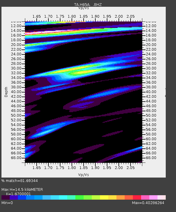
| Estimated Moho Depth: |
14.5 km |
| Estimated Crust Vp/Vs: |
1.67 |
| Assumed Crust Vp: |
6.419 km/s |
| Estimated Crust Vs: |
3.844 km/s |
| Estimated Crust Poisson's Ratio: |
0.22 |
|
| Radial Match: |
81.69344 % |
| Radial Bump: |
400 |
| Transverse Match: |
63.286892 % |
| Transverse Bump: |
400 |
| SOD ConfigId: |
751272 |
| Insert Time: |
2014-07-25 21:46:39.401 +0000 |
| GWidth: |
2.5 |
| Max Bumps: |
400 |
| Tol: |
0.001 |
|

Signal To Noise
| Channel | StoN | STA | LTA |
| TA:H65A: :BHZ:20140711T19:34:46.375005Z | 8.34386 | 7.1571776E-7 | 8.5777785E-8 |
| TA:H65A: :BHN:20140711T19:34:46.375005Z | 1.7028893 | 1.8757572E-7 | 1.1015144E-7 |
| TA:H65A: :BHE:20140711T19:34:46.375005Z | 1.2236283 | 1.027737E-7 | 8.399095E-8 |
| Arrivals |
| Ps | 1.5 SECOND |
| PpPs | 5.9 SECOND |
| PsPs/PpSs | 7.4 SECOND |


