You are here: Home > Network List > TA - USArray Transportable Network (new EarthScope stations) Stations List
> Station I61A Oroboro, Fairlee, VT, USA > Earthquake Result Viewer
I61A Oroboro, Fairlee, VT, USA - Earthquake Result Viewer
| Earthquake location: |
Off East Coast Of Honshu, Japan |
| Earthquake latitude/longitude: |
37.1/142.4 |
| Earthquake time(UTC): |
2014/07/11 (192) 19:22:00 GMT |
| Earthquake Depth: |
13 km |
| Earthquake Magnitude: |
6.8 MWP, 6.8 MI |
| Earthquake Catalog/Contributor: |
NEIC PDE/NEIC COMCAT |
|
| Network: |
TA USArray Transportable Network (new EarthScope stations) |
| Station: |
I61A Oroboro, Fairlee, VT, USA |
| Lat/Lon: |
43.93 N/72.21 W |
| Elevation: |
287 m |
|
| Distance: |
93.5 deg |
| Az: |
24.251 deg |
| Baz: |
332.953 deg |
| Ray Param: |
0.041249175 |
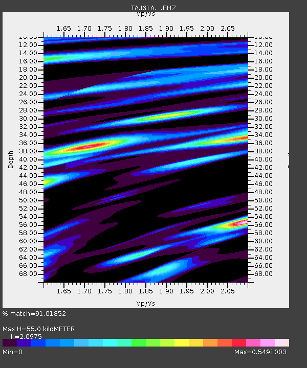
| Estimated Moho Depth: |
55.0 km |
| Estimated Crust Vp/Vs: |
2.10 |
| Assumed Crust Vp: |
6.419 km/s |
| Estimated Crust Vs: |
3.06 km/s |
| Estimated Crust Poisson's Ratio: |
0.35 |
|
| Radial Match: |
91.01852 % |
| Radial Bump: |
400 |
| Transverse Match: |
72.94173 % |
| Transverse Bump: |
400 |
| SOD ConfigId: |
751272 |
| Insert Time: |
2014-07-25 21:47:33.064 +0000 |
| GWidth: |
2.5 |
| Max Bumps: |
400 |
| Tol: |
0.001 |
|

Signal To Noise
| Channel | StoN | STA | LTA |
| TA:I61A: :BHZ:20140711T19:34:43.924993Z | 6.2121463 | 5.857476E-7 | 9.42907E-8 |
| TA:I61A: :BHN:20140711T19:34:43.924993Z | 1.8577598 | 1.7186844E-7 | 9.251381E-8 |
| TA:I61A: :BHE:20140711T19:34:43.924993Z | 1.5387317 | 1.2110337E-7 | 7.8703366E-8 |
| Arrivals |
| Ps | 9.6 SECOND |
| PpPs | 26 SECOND |
| PsPs/PpSs | 36 SECOND |


