You are here: Home > Network List > UW - Pacific Northwest Regional Seismic Network Stations List
> Station MRBL Marblemount, WA, USA > Earthquake Result Viewer
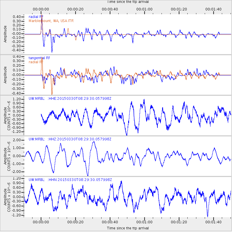
MRBL Marblemount, WA, USA - Earthquake Result Viewer
*The percent match for this event was below the threshold and hence no stack was calculated.
| Earthquake location: |
Samoa Islands Region |
| Earthquake latitude/longitude: |
-15.4/-172.9 |
| Earthquake time(UTC): |
2015/03/30 (089) 08:18:00 GMT |
| Earthquake Depth: |
10 km |
| Earthquake Magnitude: |
6.8 MWP, 6.8 MI |
| Earthquake Catalog/Contributor: |
NEIC PDE/NEIC COMCAT |
|
| Network: |
UW Pacific Northwest Regional Seismic Network |
| Station: |
MRBL Marblemount, WA, USA |
| Lat/Lon: |
48.52 N/121.48 W |
| Elevation: |
75 m |
|
| Distance: |
78.3 deg |
| Az: |
32.061 deg |
| Baz: |
230.358 deg |
| Ray Param: |
$rayparam |
*The percent match for this event was below the threshold and hence was not used in the summary stack. |
|
| Radial Match: |
70.004005 % |
| Radial Bump: |
400 |
| Transverse Match: |
59.020416 % |
| Transverse Bump: |
400 |
| SOD ConfigId: |
7422571 |
| Insert Time: |
2019-04-18 00:02:49.794 +0000 |
| GWidth: |
2.5 |
| Max Bumps: |
400 |
| Tol: |
0.001 |
|
Signal To Noise
| Channel | StoN | STA | LTA |
| UW:MRBL: :HHZ:20150330T08:29:30.057998Z | 2.3848965 | 7.4264386E-7 | 3.113946E-7 |
| UW:MRBL: :HHN:20150330T08:29:30.057998Z | 0.6115092 | 2.6398405E-7 | 4.316927E-7 |
| UW:MRBL: :HHE:20150330T08:29:30.057998Z | 1.6102794 | 4.5037487E-7 | 2.796874E-7 |
| Arrivals |
| Ps | |
| PpPs | |
| PsPs/PpSs | |


