You are here: Home > Network List > TA - USArray Transportable Network (new EarthScope stations) Stations List
> Station J63A Strafford, NH, USA > Earthquake Result Viewer
J63A Strafford, NH, USA - Earthquake Result Viewer
| Earthquake location: |
Off East Coast Of Honshu, Japan |
| Earthquake latitude/longitude: |
37.1/142.4 |
| Earthquake time(UTC): |
2014/07/11 (192) 19:22:00 GMT |
| Earthquake Depth: |
13 km |
| Earthquake Magnitude: |
6.8 MWP, 6.8 MI |
| Earthquake Catalog/Contributor: |
NEIC PDE/NEIC COMCAT |
|
| Network: |
TA USArray Transportable Network (new EarthScope stations) |
| Station: |
J63A Strafford, NH, USA |
| Lat/Lon: |
43.28 N/71.08 W |
| Elevation: |
142 m |
|
| Distance: |
94.4 deg |
| Az: |
23.809 deg |
| Baz: |
333.761 deg |
| Ray Param: |
0.041041113 |
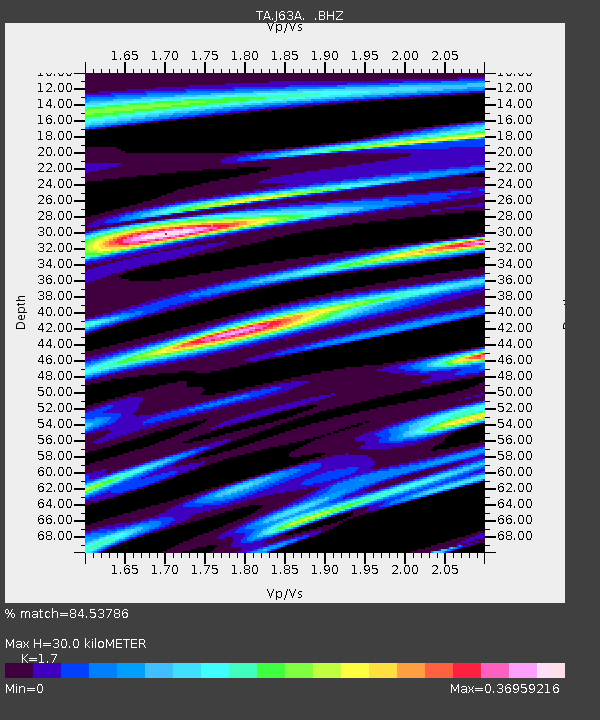
| Estimated Moho Depth: |
30.0 km |
| Estimated Crust Vp/Vs: |
1.70 |
| Assumed Crust Vp: |
6.419 km/s |
| Estimated Crust Vs: |
3.776 km/s |
| Estimated Crust Poisson's Ratio: |
0.24 |
|
| Radial Match: |
84.53786 % |
| Radial Bump: |
400 |
| Transverse Match: |
69.64203 % |
| Transverse Bump: |
400 |
| SOD ConfigId: |
751272 |
| Insert Time: |
2014-07-25 21:48:39.738 +0000 |
| GWidth: |
2.5 |
| Max Bumps: |
400 |
| Tol: |
0.001 |
|

Signal To Noise
| Channel | StoN | STA | LTA |
| TA:J63A: :BHZ:20140711T19:34:48.275029Z | 4.658309 | 5.1552564E-7 | 1.1066798E-7 |
| TA:J63A: :BHN:20140711T19:34:48.275029Z | 1.6294004 | 1.2372855E-7 | 7.593502E-8 |
| TA:J63A: :BHE:20140711T19:34:48.275029Z | 1.4103994 | 1.2107162E-7 | 8.5842075E-8 |
| Arrivals |
| Ps | 3.3 SECOND |
| PpPs | 12 SECOND |
| PsPs/PpSs | 16 SECOND |


