You are here: Home > Network List > YT07 - POLENET Stations List
> Station HOWE HOWE > Earthquake Result Viewer
HOWE HOWE - Earthquake Result Viewer
| Earthquake location: |
Samoa Islands Region |
| Earthquake latitude/longitude: |
-15.4/-172.9 |
| Earthquake time(UTC): |
2015/03/30 (089) 08:18:00 GMT |
| Earthquake Depth: |
10 km |
| Earthquake Magnitude: |
6.8 MWP, 6.8 MI |
| Earthquake Catalog/Contributor: |
NEIC PDE/NEIC COMCAT |
|
| Network: |
YT POLENET |
| Station: |
HOWE HOWE |
| Lat/Lon: |
87.42 S/149.43 W |
| Elevation: |
2607 m |
|
| Distance: |
72.3 deg |
| Az: |
178.912 deg |
| Baz: |
336.204 deg |
| Ray Param: |
0.053749375 |
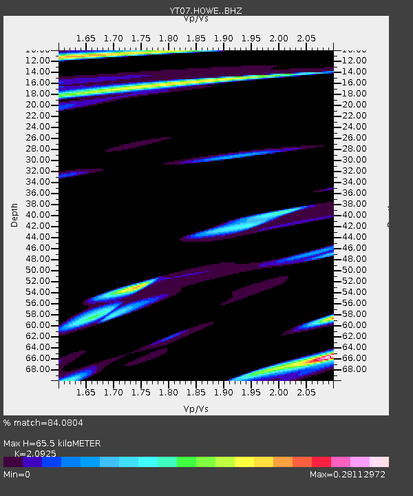
| Estimated Moho Depth: |
65.5 km |
| Estimated Crust Vp/Vs: |
2.09 |
| Assumed Crust Vp: |
6.182 km/s |
| Estimated Crust Vs: |
2.954 km/s |
| Estimated Crust Poisson's Ratio: |
0.35 |
|
| Radial Match: |
84.0804 % |
| Radial Bump: |
334 |
| Transverse Match: |
64.24504 % |
| Transverse Bump: |
400 |
| SOD ConfigId: |
7422571 |
| Insert Time: |
2019-04-18 00:03:46.611 +0000 |
| GWidth: |
2.5 |
| Max Bumps: |
400 |
| Tol: |
0.001 |
|

Signal To Noise
| Channel | StoN | STA | LTA |
| YT:HOWE: :BHZ:20150330T08:28:55.325027Z | 2.9825656 | 6.3200315E-7 | 2.1189915E-7 |
| YT:HOWE: :BHN:20150330T08:28:55.325027Z | 1.0366365 | 2.4586362E-7 | 2.3717438E-7 |
| YT:HOWE: :BHE:20150330T08:28:55.325027Z | 1.4602302 | 3.1516652E-7 | 2.1583345E-7 |
| Arrivals |
| Ps | 12 SECOND |
| PpPs | 32 SECOND |
| PsPs/PpSs | 44 SECOND |


