You are here: Home > Network List > TA - USArray Transportable Network (new EarthScope stations) Stations List
> Station N56A West Decatur, PA, USA > Earthquake Result Viewer
N56A West Decatur, PA, USA - Earthquake Result Viewer
| Earthquake location: |
Off East Coast Of Honshu, Japan |
| Earthquake latitude/longitude: |
37.1/142.4 |
| Earthquake time(UTC): |
2014/07/11 (192) 19:22:00 GMT |
| Earthquake Depth: |
13 km |
| Earthquake Magnitude: |
6.8 MWP, 6.8 MI |
| Earthquake Catalog/Contributor: |
NEIC PDE/NEIC COMCAT |
|
| Network: |
TA USArray Transportable Network (new EarthScope stations) |
| Station: |
N56A West Decatur, PA, USA |
| Lat/Lon: |
40.92 N/78.30 W |
| Elevation: |
561 m |
|
| Distance: |
93.9 deg |
| Az: |
29.665 deg |
| Baz: |
328.509 deg |
| Ray Param: |
0.041163467 |
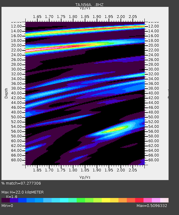
| Estimated Moho Depth: |
22.0 km |
| Estimated Crust Vp/Vs: |
1.60 |
| Assumed Crust Vp: |
6.121 km/s |
| Estimated Crust Vs: |
3.825 km/s |
| Estimated Crust Poisson's Ratio: |
0.18 |
|
| Radial Match: |
87.277306 % |
| Radial Bump: |
366 |
| Transverse Match: |
61.744217 % |
| Transverse Bump: |
400 |
| SOD ConfigId: |
751272 |
| Insert Time: |
2014-07-25 21:52:40.122 +0000 |
| GWidth: |
2.5 |
| Max Bumps: |
400 |
| Tol: |
0.001 |
|
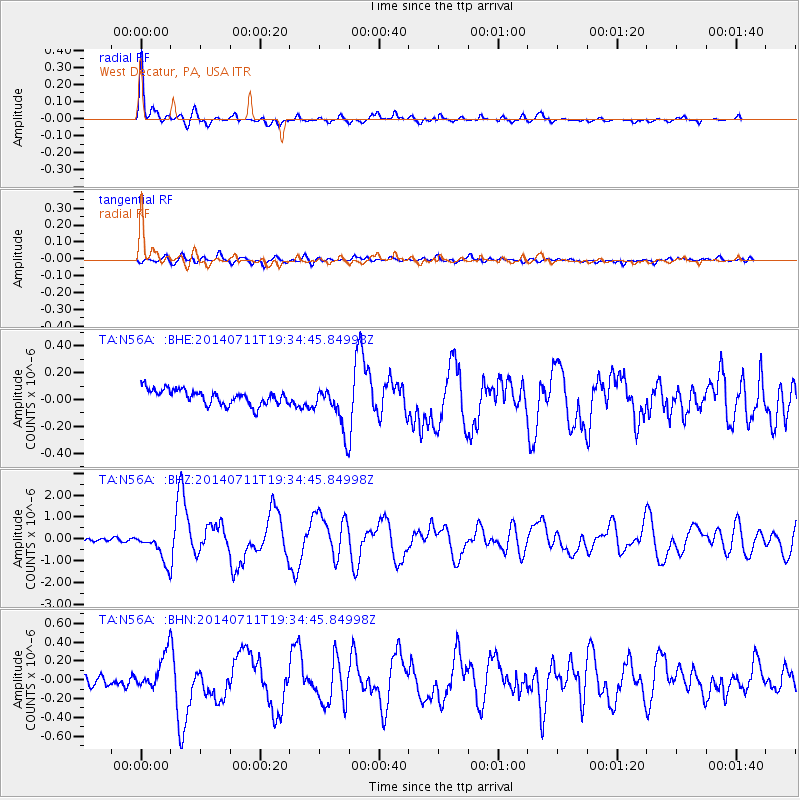
Signal To Noise
| Channel | StoN | STA | LTA |
| TA:N56A: :BHZ:20140711T19:34:45.84998Z | 11.485979 | 6.7804194E-7 | 5.9032136E-8 |
| TA:N56A: :BHN:20140711T19:34:45.84998Z | 2.5435524 | 1.7309132E-7 | 6.805101E-8 |
| TA:N56A: :BHE:20140711T19:34:45.84998Z | 3.017436 | 1.6723561E-7 | 5.5423087E-8 |
| Arrivals |
| Ps | 2.2 SECOND |
| PpPs | 9.2 SECOND |
| PsPs/PpSs | 11 SECOND |


