You are here: Home > Network List > TA - USArray Transportable Network (new EarthScope stations) Stations List
> Station P54A Burton, WV, USA > Earthquake Result Viewer
P54A Burton, WV, USA - Earthquake Result Viewer
| Earthquake location: |
Off East Coast Of Honshu, Japan |
| Earthquake latitude/longitude: |
37.1/142.4 |
| Earthquake time(UTC): |
2014/07/11 (192) 19:22:00 GMT |
| Earthquake Depth: |
13 km |
| Earthquake Magnitude: |
6.8 MWP, 6.8 MI |
| Earthquake Catalog/Contributor: |
NEIC PDE/NEIC COMCAT |
|
| Network: |
TA USArray Transportable Network (new EarthScope stations) |
| Station: |
P54A Burton, WV, USA |
| Lat/Lon: |
39.61 N/80.48 W |
| Elevation: |
473 m |
|
| Distance: |
94.1 deg |
| Az: |
31.781 deg |
| Baz: |
326.954 deg |
| Ray Param: |
0.0411153 |
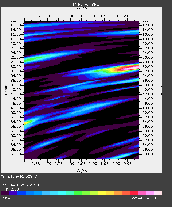
| Estimated Moho Depth: |
30.25 km |
| Estimated Crust Vp/Vs: |
2.08 |
| Assumed Crust Vp: |
6.207 km/s |
| Estimated Crust Vs: |
2.984 km/s |
| Estimated Crust Poisson's Ratio: |
0.35 |
|
| Radial Match: |
92.00843 % |
| Radial Bump: |
400 |
| Transverse Match: |
61.838726 % |
| Transverse Bump: |
400 |
| SOD ConfigId: |
751272 |
| Insert Time: |
2014-07-25 21:54:43.930 +0000 |
| GWidth: |
2.5 |
| Max Bumps: |
400 |
| Tol: |
0.001 |
|
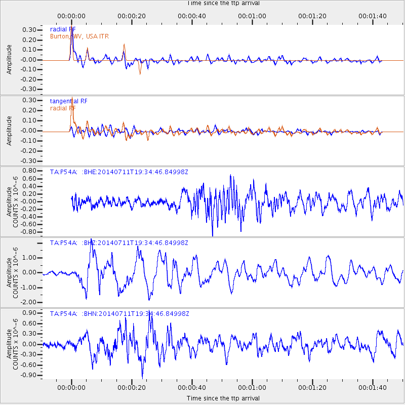
Signal To Noise
| Channel | StoN | STA | LTA |
| TA:P54A: :BHZ:20140711T19:34:46.84998Z | 5.685893 | 5.966138E-7 | 1.0492877E-7 |
| TA:P54A: :BHN:20140711T19:34:46.84998Z | 1.6779567 | 1.3318635E-7 | 7.9374125E-8 |
| TA:P54A: :BHE:20140711T19:34:46.84998Z | 0.9281305 | 8.411671E-8 | 9.063026E-8 |
| Arrivals |
| Ps | 5.3 SECOND |
| PpPs | 15 SECOND |
| PsPs/PpSs | 20 SECOND |


