You are here: Home > Network List > TA - USArray Transportable Network (new EarthScope stations) Stations List
> Station Q57A Strasburg, VA, USA > Earthquake Result Viewer
Q57A Strasburg, VA, USA - Earthquake Result Viewer
| Earthquake location: |
Off East Coast Of Honshu, Japan |
| Earthquake latitude/longitude: |
37.1/142.4 |
| Earthquake time(UTC): |
2014/07/11 (192) 19:22:00 GMT |
| Earthquake Depth: |
13 km |
| Earthquake Magnitude: |
6.8 MWP, 6.8 MI |
| Earthquake Catalog/Contributor: |
NEIC PDE/NEIC COMCAT |
|
| Network: |
TA USArray Transportable Network (new EarthScope stations) |
| Station: |
Q57A Strasburg, VA, USA |
| Lat/Lon: |
39.04 N/78.41 W |
| Elevation: |
324 m |
|
| Distance: |
95.5 deg |
| Az: |
30.728 deg |
| Baz: |
328.348 deg |
| Ray Param: |
0.04077276 |
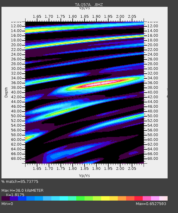
| Estimated Moho Depth: |
36.0 km |
| Estimated Crust Vp/Vs: |
1.92 |
| Assumed Crust Vp: |
6.159 km/s |
| Estimated Crust Vs: |
3.212 km/s |
| Estimated Crust Poisson's Ratio: |
0.31 |
|
| Radial Match: |
85.73775 % |
| Radial Bump: |
400 |
| Transverse Match: |
71.523155 % |
| Transverse Bump: |
400 |
| SOD ConfigId: |
751272 |
| Insert Time: |
2014-07-25 21:55:41.835 +0000 |
| GWidth: |
2.5 |
| Max Bumps: |
400 |
| Tol: |
0.001 |
|

Signal To Noise
| Channel | StoN | STA | LTA |
| TA:Q57A: :BHZ:20140711T19:34:52.924993Z | 7.3707943 | 4.497487E-7 | 6.101767E-8 |
| TA:Q57A: :BHN:20140711T19:34:52.924993Z | 3.7056556 | 1.2491752E-7 | 3.3709963E-8 |
| TA:Q57A: :BHE:20140711T19:34:52.924993Z | 2.1350598 | 7.509265E-8 | 3.5171215E-8 |
| Arrivals |
| Ps | 5.5 SECOND |
| PpPs | 17 SECOND |
| PsPs/PpSs | 22 SECOND |


