You are here: Home > Network List > TA - USArray Transportable Network (new EarthScope stations) Stations List
> Station Q59A Harwood, MD, USA > Earthquake Result Viewer
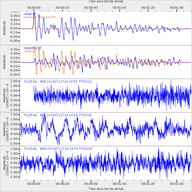
Q59A Harwood, MD, USA - Earthquake Result Viewer
*The percent match for this event was below the threshold and hence no stack was calculated.
| Earthquake location: |
Off East Coast Of Honshu, Japan |
| Earthquake latitude/longitude: |
37.1/142.4 |
| Earthquake time(UTC): |
2014/07/11 (192) 19:22:00 GMT |
| Earthquake Depth: |
13 km |
| Earthquake Magnitude: |
6.8 MWP, 6.8 MI |
| Earthquake Catalog/Contributor: |
NEIC PDE/NEIC COMCAT |
|
| Network: |
TA USArray Transportable Network (new EarthScope stations) |
| Station: |
Q59A Harwood, MD, USA |
| Lat/Lon: |
38.86 N/76.65 W |
| Elevation: |
34 m |
|
| Distance: |
96.3 deg |
| Az: |
29.637 deg |
| Baz: |
329.559 deg |
| Ray Param: |
$rayparam |
*The percent match for this event was below the threshold and hence was not used in the summary stack. |
|
| Radial Match: |
78.13985 % |
| Radial Bump: |
400 |
| Transverse Match: |
50.563663 % |
| Transverse Bump: |
400 |
| SOD ConfigId: |
751272 |
| Insert Time: |
2014-07-25 21:55:49.933 +0000 |
| GWidth: |
2.5 |
| Max Bumps: |
400 |
| Tol: |
0.001 |
|
Signal To Noise
| Channel | StoN | STA | LTA |
| TA:Q59A: :BHZ:20140711T19:34:56.775029Z | 1.9563254 | 5.5021025E-7 | 2.8124677E-7 |
| TA:Q59A: :BHN:20140711T19:34:56.775029Z | 1.0170304 | 3.967201E-7 | 3.9007693E-7 |
| TA:Q59A: :BHE:20140711T19:34:56.775029Z | 1.1255941 | 4.5637614E-7 | 4.0545356E-7 |
| Arrivals |
| Ps | |
| PpPs | |
| PsPs/PpSs | |


