You are here: Home > Network List > TA - USArray Transportable Network (new EarthScope stations) Stations List
> Station J04D Umpqua National Forest, Toketee, OR, USA > Earthquake Result Viewer
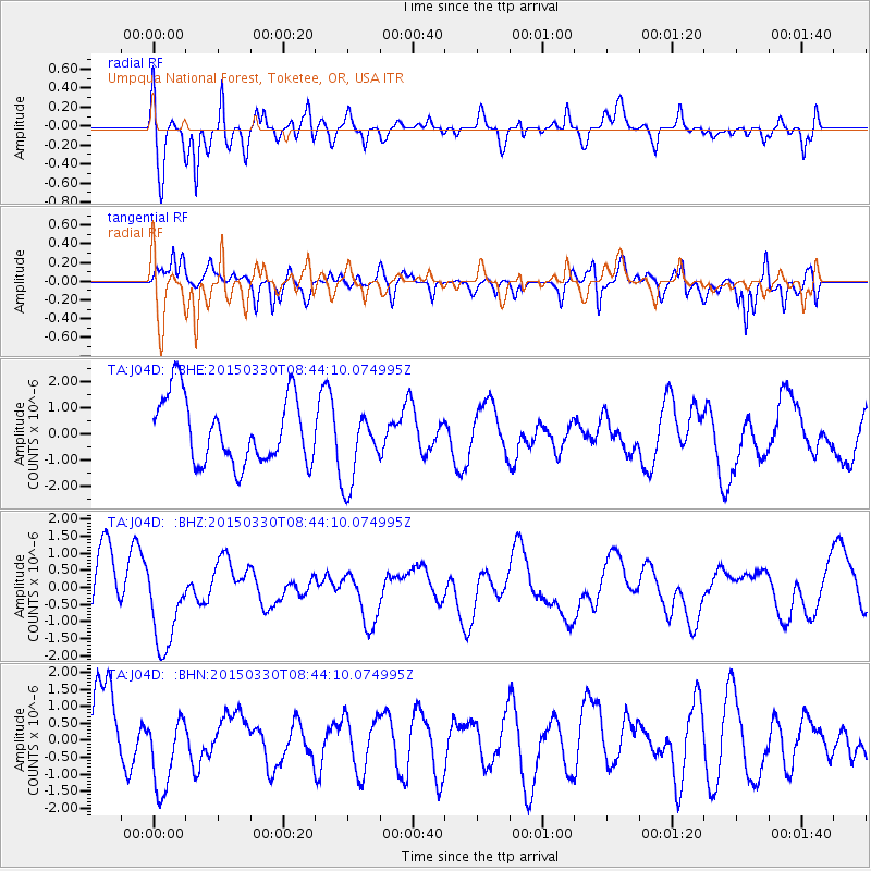
J04D Umpqua National Forest, Toketee, OR, USA - Earthquake Result Viewer
*The percent match for this event was below the threshold and hence no stack was calculated.
| Earthquake location: |
New Britain Region, P.N.G. |
| Earthquake latitude/longitude: |
-4.7/152.6 |
| Earthquake time(UTC): |
2015/03/30 (089) 08:31:46 GMT |
| Earthquake Depth: |
35 km |
| Earthquake Magnitude: |
5.3 mb, 5.2 mb, 5.7 MS |
| Earthquake Catalog/Contributor: |
ISC/ISC |
|
| Network: |
TA USArray Transportable Network (new EarthScope stations) |
| Station: |
J04D Umpqua National Forest, Toketee, OR, USA |
| Lat/Lon: |
43.24 N/122.11 W |
| Elevation: |
1948 m |
|
| Distance: |
89.8 deg |
| Az: |
46.748 deg |
| Baz: |
263.423 deg |
| Ray Param: |
$rayparam |
*The percent match for this event was below the threshold and hence was not used in the summary stack. |
|
| Radial Match: |
73.5917 % |
| Radial Bump: |
400 |
| Transverse Match: |
62.3458 % |
| Transverse Bump: |
400 |
| SOD ConfigId: |
7422571 |
| Insert Time: |
2019-04-18 00:07:26.966 +0000 |
| GWidth: |
2.5 |
| Max Bumps: |
400 |
| Tol: |
0.001 |
|
Signal To Noise
| Channel | StoN | STA | LTA |
| TA:J04D: :BHZ:20150330T08:44:10.074995Z | 1.8472658 | 1.3463286E-6 | 7.288224E-7 |
| TA:J04D: :BHN:20150330T08:44:10.074995Z | 1.0807799 | 1.1191875E-6 | 1.0355368E-6 |
| TA:J04D: :BHE:20150330T08:44:10.074995Z | 1.1540382 | 1.465544E-6 | 1.2699268E-6 |
| Arrivals |
| Ps | |
| PpPs | |
| PsPs/PpSs | |


