You are here: Home > Network List > TA - USArray Transportable Network (new EarthScope stations) Stations List
> Station T54A Tazewell, VA, USA > Earthquake Result Viewer
T54A Tazewell, VA, USA - Earthquake Result Viewer
| Earthquake location: |
Off East Coast Of Honshu, Japan |
| Earthquake latitude/longitude: |
37.1/142.4 |
| Earthquake time(UTC): |
2014/07/11 (192) 19:22:00 GMT |
| Earthquake Depth: |
13 km |
| Earthquake Magnitude: |
6.8 MWP, 6.8 MI |
| Earthquake Catalog/Contributor: |
NEIC PDE/NEIC COMCAT |
|
| Network: |
TA USArray Transportable Network (new EarthScope stations) |
| Station: |
T54A Tazewell, VA, USA |
| Lat/Lon: |
37.06 N/81.58 W |
| Elevation: |
852 m |
|
| Distance: |
95.8 deg |
| Az: |
33.911 deg |
| Baz: |
326.093 deg |
| Ray Param: |
0.040692057 |
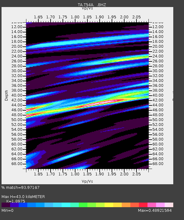
| Estimated Moho Depth: |
43.0 km |
| Estimated Crust Vp/Vs: |
1.90 |
| Assumed Crust Vp: |
6.159 km/s |
| Estimated Crust Vs: |
3.246 km/s |
| Estimated Crust Poisson's Ratio: |
0.31 |
|
| Radial Match: |
93.97167 % |
| Radial Bump: |
378 |
| Transverse Match: |
81.981476 % |
| Transverse Bump: |
400 |
| SOD ConfigId: |
751272 |
| Insert Time: |
2014-07-25 21:57:33.222 +0000 |
| GWidth: |
2.5 |
| Max Bumps: |
400 |
| Tol: |
0.001 |
|
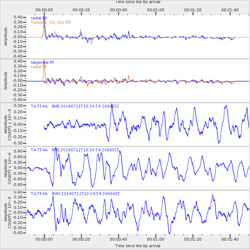
Signal To Noise
| Channel | StoN | STA | LTA |
| TA:T54A: :BHZ:20140711T19:34:54.299993Z | 8.584302 | 4.082829E-7 | 4.7561574E-8 |
| TA:T54A: :BHN:20140711T19:34:54.299993Z | 2.4640713 | 1.1883491E-7 | 4.822706E-8 |
| TA:T54A: :BHE:20140711T19:34:54.299993Z | 3.1757708 | 1.0395012E-7 | 3.2732252E-8 |
| Arrivals |
| Ps | 6.4 SECOND |
| PpPs | 20 SECOND |
| PsPs/PpSs | 26 SECOND |


