You are here: Home > Network List > TA - USArray Transportable Network (new EarthScope stations) Stations List
> Station T60A Surry, VA, USA > Earthquake Result Viewer
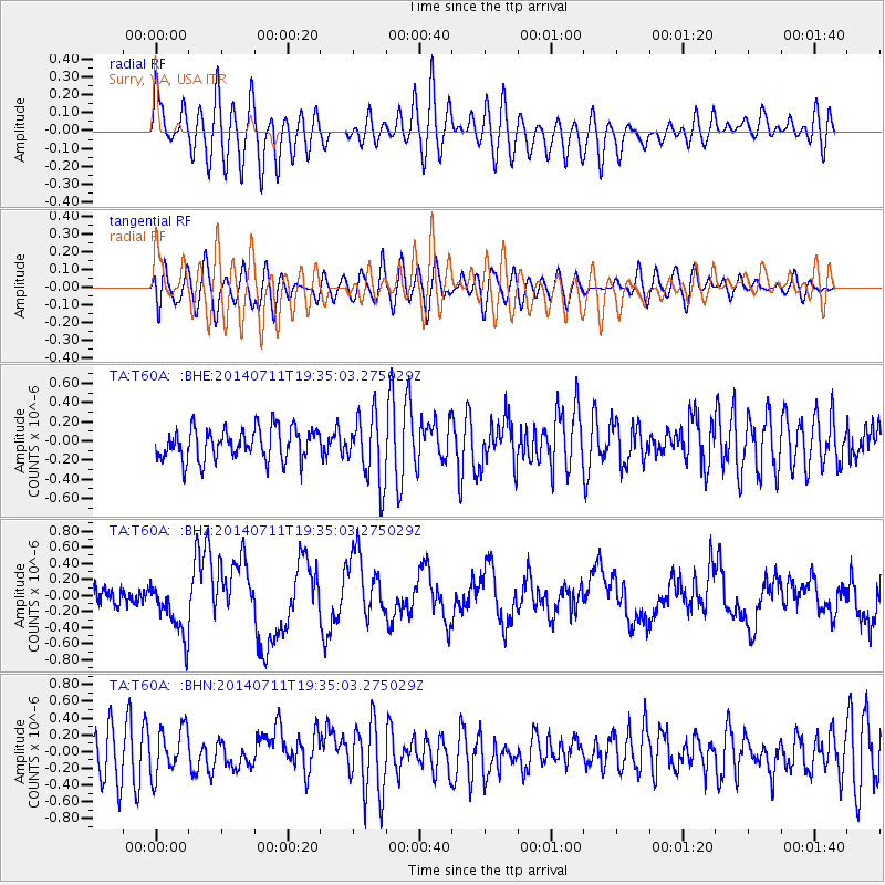
T60A Surry, VA, USA - Earthquake Result Viewer
*The percent match for this event was below the threshold and hence no stack was calculated.
| Earthquake location: |
Off East Coast Of Honshu, Japan |
| Earthquake latitude/longitude: |
37.1/142.4 |
| Earthquake time(UTC): |
2014/07/11 (192) 19:22:00 GMT |
| Earthquake Depth: |
13 km |
| Earthquake Magnitude: |
6.8 MWP, 6.8 MI |
| Earthquake Catalog/Contributor: |
NEIC PDE/NEIC COMCAT |
|
| Network: |
TA USArray Transportable Network (new EarthScope stations) |
| Station: |
T60A Surry, VA, USA |
| Lat/Lon: |
37.14 N/76.73 W |
| Elevation: |
11 m |
|
| Distance: |
97.8 deg |
| Az: |
30.573 deg |
| Baz: |
329.396 deg |
| Ray Param: |
$rayparam |
*The percent match for this event was below the threshold and hence was not used in the summary stack. |
|
| Radial Match: |
48.12848 % |
| Radial Bump: |
400 |
| Transverse Match: |
40.358685 % |
| Transverse Bump: |
400 |
| SOD ConfigId: |
751272 |
| Insert Time: |
2014-07-25 21:57:58.902 +0000 |
| GWidth: |
2.5 |
| Max Bumps: |
400 |
| Tol: |
0.001 |
|
Signal To Noise
| Channel | StoN | STA | LTA |
| TA:T60A: :BHZ:20140711T19:35:03.275029Z | 3.4303951 | 3.4415376E-7 | 1.0032482E-7 |
| TA:T60A: :BHN:20140711T19:35:03.275029Z | 1.3487042 | 2.810968E-7 | 2.0841988E-7 |
| TA:T60A: :BHE:20140711T19:35:03.275029Z | 2.1334608 | 3.5148207E-7 | 1.6474739E-7 |
| Arrivals |
| Ps | |
| PpPs | |
| PsPs/PpSs | |


