You are here: Home > Network List > TA - USArray Transportable Network (new EarthScope stations) Stations List
> Station V56A Mocksville, NC, USA > Earthquake Result Viewer
V56A Mocksville, NC, USA - Earthquake Result Viewer
| Earthquake location: |
Off East Coast Of Honshu, Japan |
| Earthquake latitude/longitude: |
37.1/142.4 |
| Earthquake time(UTC): |
2014/07/11 (192) 19:22:00 GMT |
| Earthquake Depth: |
13 km |
| Earthquake Magnitude: |
6.8 MWP, 6.8 MI |
| Earthquake Catalog/Contributor: |
NEIC PDE/NEIC COMCAT |
|
| Network: |
TA USArray Transportable Network (new EarthScope stations) |
| Station: |
V56A Mocksville, NC, USA |
| Lat/Lon: |
35.81 N/80.50 W |
| Elevation: |
237 m |
|
| Distance: |
97.3 deg |
| Az: |
33.876 deg |
| Baz: |
326.735 deg |
| Ray Param: |
0.040255938 |
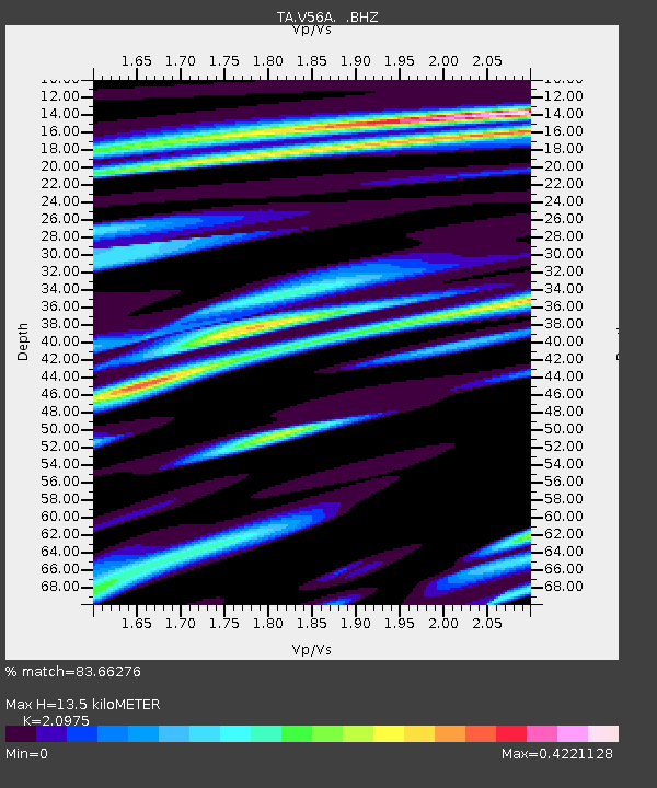
| Estimated Moho Depth: |
13.5 km |
| Estimated Crust Vp/Vs: |
2.10 |
| Assumed Crust Vp: |
6.419 km/s |
| Estimated Crust Vs: |
3.06 km/s |
| Estimated Crust Poisson's Ratio: |
0.35 |
|
| Radial Match: |
83.66276 % |
| Radial Bump: |
400 |
| Transverse Match: |
71.13449 % |
| Transverse Bump: |
400 |
| SOD ConfigId: |
751272 |
| Insert Time: |
2014-07-25 21:59:00.215 +0000 |
| GWidth: |
2.5 |
| Max Bumps: |
400 |
| Tol: |
0.001 |
|
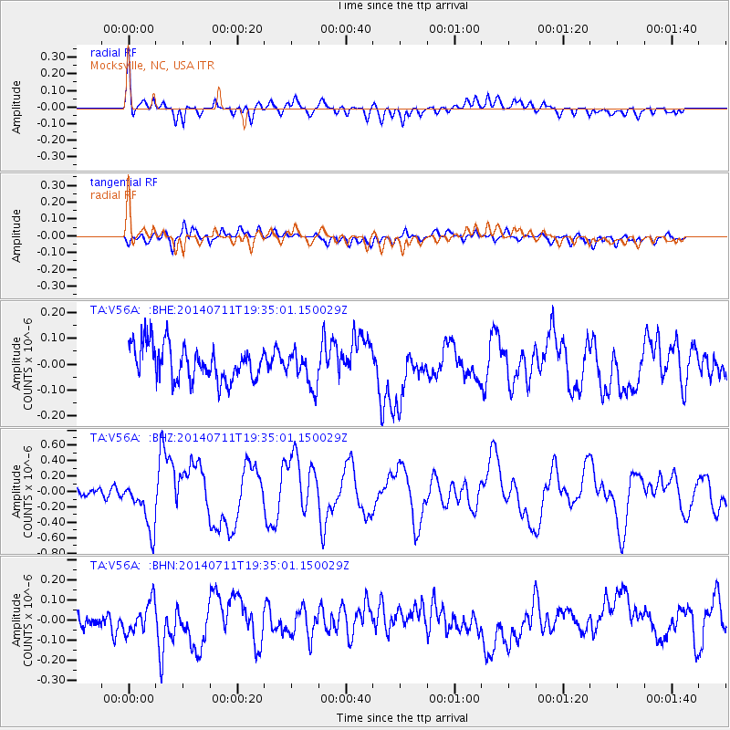
Signal To Noise
| Channel | StoN | STA | LTA |
| TA:V56A: :BHZ:20140711T19:35:01.150029Z | 6.358723 | 3.3113375E-7 | 5.2075507E-8 |
| TA:V56A: :BHN:20140711T19:35:01.150029Z | 2.113314 | 7.679674E-8 | 3.6339483E-8 |
| TA:V56A: :BHE:20140711T19:35:01.150029Z | 1.0244356 | 6.9108935E-8 | 6.746049E-8 |
| Arrivals |
| Ps | 2.3 SECOND |
| PpPs | 6.4 SECOND |
| PsPs/PpSs | 8.8 SECOND |


