You are here: Home > Network List > TA - USArray Transportable Network (new EarthScope stations) Stations List
> Station W57A Gilead, NC, USA > Earthquake Result Viewer
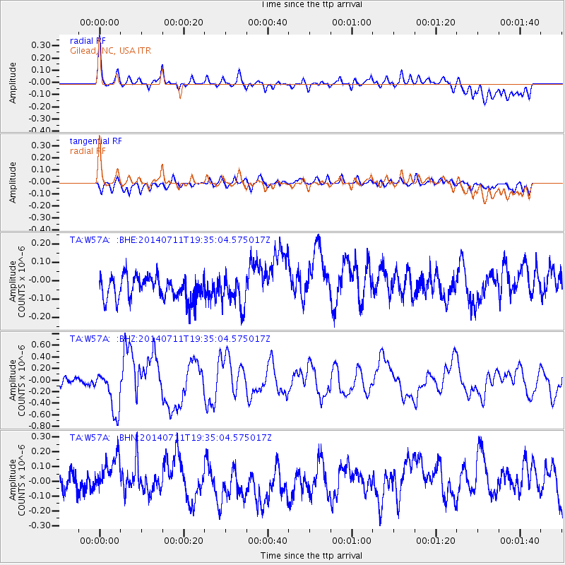
W57A Gilead, NC, USA - Earthquake Result Viewer
*The percent match for this event was below the threshold and hence no stack was calculated.
| Earthquake location: |
Off East Coast Of Honshu, Japan |
| Earthquake latitude/longitude: |
37.1/142.4 |
| Earthquake time(UTC): |
2014/07/11 (192) 19:22:00 GMT |
| Earthquake Depth: |
13 km |
| Earthquake Magnitude: |
6.8 MWP, 6.8 MI |
| Earthquake Catalog/Contributor: |
NEIC PDE/NEIC COMCAT |
|
| Network: |
TA USArray Transportable Network (new EarthScope stations) |
| Station: |
W57A Gilead, NC, USA |
| Lat/Lon: |
35.15 N/79.99 W |
| Elevation: |
85 m |
|
| Distance: |
98.1 deg |
| Az: |
33.89 deg |
| Baz: |
327.025 deg |
| Ray Param: |
$rayparam |
*The percent match for this event was below the threshold and hence was not used in the summary stack. |
|
| Radial Match: |
65.504 % |
| Radial Bump: |
400 |
| Transverse Match: |
42.30028 % |
| Transverse Bump: |
400 |
| SOD ConfigId: |
751272 |
| Insert Time: |
2014-07-25 21:59:35.604 +0000 |
| GWidth: |
2.5 |
| Max Bumps: |
400 |
| Tol: |
0.001 |
|
Signal To Noise
| Channel | StoN | STA | LTA |
| TA:W57A: :BHZ:20140711T19:35:04.575017Z | 7.4787774 | 3.7988875E-7 | 5.079557E-8 |
| TA:W57A: :BHN:20140711T19:35:04.575017Z | 1.6632304 | 1.646372E-7 | 9.8986405E-8 |
| TA:W57A: :BHE:20140711T19:35:04.575017Z | 1.2984282 | 8.157158E-8 | 6.2823325E-8 |
| Arrivals |
| Ps | |
| PpPs | |
| PsPs/PpSs | |


