You are here: Home > Network List > TA - USArray Transportable Network (new EarthScope stations) Stations List
> Station Y12C Blythe, CA, USA > Earthquake Result Viewer
Y12C Blythe, CA, USA - Earthquake Result Viewer
| Earthquake location: |
Off East Coast Of Honshu, Japan |
| Earthquake latitude/longitude: |
37.1/142.4 |
| Earthquake time(UTC): |
2014/07/11 (192) 19:22:00 GMT |
| Earthquake Depth: |
13 km |
| Earthquake Magnitude: |
6.8 MWP, 6.8 MI |
| Earthquake Catalog/Contributor: |
NEIC PDE/NEIC COMCAT |
|
| Network: |
TA USArray Transportable Network (new EarthScope stations) |
| Station: |
Y12C Blythe, CA, USA |
| Lat/Lon: |
33.75 N/114.52 W |
| Elevation: |
196 m |
|
| Distance: |
79.6 deg |
| Az: |
55.593 deg |
| Baz: |
307.624 deg |
| Ray Param: |
0.048851945 |
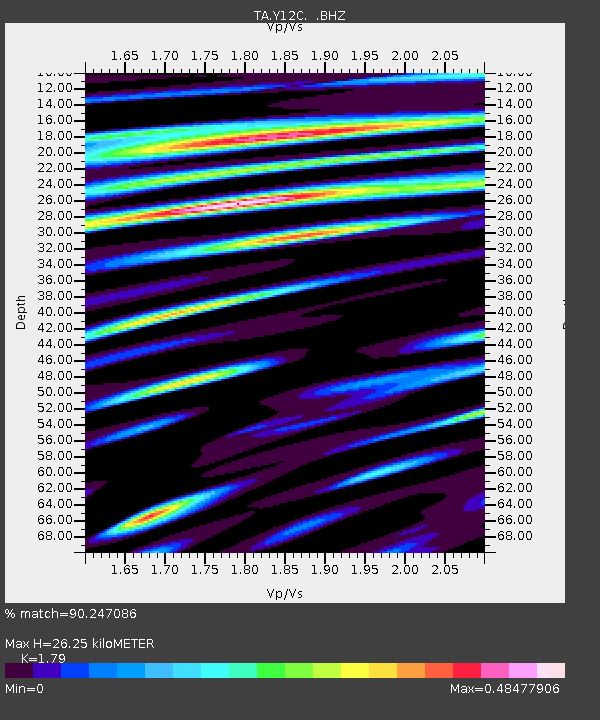
| Estimated Moho Depth: |
26.25 km |
| Estimated Crust Vp/Vs: |
1.79 |
| Assumed Crust Vp: |
6.155 km/s |
| Estimated Crust Vs: |
3.438 km/s |
| Estimated Crust Poisson's Ratio: |
0.27 |
|
| Radial Match: |
90.247086 % |
| Radial Bump: |
400 |
| Transverse Match: |
76.36531 % |
| Transverse Bump: |
400 |
| SOD ConfigId: |
751272 |
| Insert Time: |
2014-07-25 22:00:03.652 +0000 |
| GWidth: |
2.5 |
| Max Bumps: |
400 |
| Tol: |
0.001 |
|

Signal To Noise
| Channel | StoN | STA | LTA |
| TA:Y12C: :BHZ:20140711T19:33:35.619023Z | 4.067674 | 2.7934212E-7 | 6.867368E-8 |
| TA:Y12C: :BHN:20140711T19:33:35.619023Z | 1.5591648 | 1.0097103E-7 | 6.475969E-8 |
| TA:Y12C: :BHE:20140711T19:33:35.619023Z | 1.232087 | 1.0480944E-7 | 8.506659E-8 |
| Arrivals |
| Ps | 3.5 SECOND |
| PpPs | 12 SECOND |
| PsPs/PpSs | 15 SECOND |


